

Country profile
Nepal at a glance
Geography, population, money, climate and the practical facts worth knowing before you arrive.
Nepal is a landlocked republic of 147,516 km² between China and India, with 29,164,578 people at the 2021 census and eight of the world's fourteen 8,000 m peaks, Everest among them at its officially agreed 8,848.86 m. Below: elevation bands, provinces, the rupee peg, the seasons, the UNESCO list, the airports that actually work in 2026, and the practical basics.
Where is Nepal and how big is it?
Nepal covers 147,516 km² between 26°22′N and 30°27′N: roughly 1,236 km of border with Tibet to the north, 1,690 km with India on the other three sides. It runs 800 to 885 km east to west but only 150 to 250 km north to south, so the ground climbs from 60 m to 8,848.86 m across a short drive. You will also see 147,181 km², an older government figure.
Three ecological belts run east to west:
- Terai. Southern plains, 60 to 305 m, about 17% of the land area; lowest point Kechana Kalan, Jhapa.
- Hill region (Pahad). Siwalik 700 to 1,500 m, Mahabharat 1,500 to 2,700 m, midland valleys (Kathmandu, Pokhara) to about 3,500 m.
- Himalaya. Above about 3,000 m, treeline near 4,000 m, permanent snow from 5,000 to 5,500 m.
How tall is Mount Everest, officially?
Mount Everest is 8,848.86 m (29,031.7 ft). Nepal and China announced it jointly on 8 December 2020, the first agreed figure in either country's history, after surveys using GPS, ground-penetrating radar and gravimeters.
8,848 m is the superseded pre-2020 figure, not a rounding of the current one. Plenty of sites still print it, official Nepali ones included.
Eight of the fourteen 8,000 m peaks stand wholly or partly in Nepal:
| Peak | Height | Note |
|---|---|---|
| Everest (Sagarmatha) | 8,848.86 m | Tibet border crosses the summit |
| Kanchenjunga | 8,586 m | Shared with India |
| Lhotse | 8,516 m | Everest massif |
| Makalu | 8,463 m | Makalu Barun |
| Cho Oyu | 8,201 m | Shared with Tibet |
| Dhaulagiri I | 8,167 m | Wholly in Nepal |
| Manaslu | 8,163 m | Wholly in Nepal |
| Annapurna I | 8,091 m | Wholly in Nepal |
Nepal's own tally of 14, adopted in 2025, counts subsidiary summits and is not recognised internationally. Route detail sits on our Everest region and Annapurna region pages and the Everest Base Camp trek.
How many people live in Nepal, and how is it governed?
The 2021 census counted 29,164,578 people on 25 November 2021: 14,253,551 male, 14,911,027 female, growing 0.92% a year at 198 per km². Kathmandu, Lalitpur and Bhaktapur districts held 3,025,386 between them. UN projections put mid-2026 near 29.63 million, a projection, not a count.
Nepal has been a federal republic since the 2015 Constitution: 7 provinces (Koshi, Madhesh, Bagmati, Gandaki, Lumbini, Karnali, Sudurpashchim), 77 districts and 753 local levels. The capital, Kathmandu, is in Bagmati.
The census "urban" share of 66.17% reflects the 2017 reclassification of local units, not density; real urbanisation is nearer 20%.
What languages and religions does Nepal have?
Nepali is the official language and the mother tongue of 44.86% of the population, out of 124 mother tongues recorded in the 2021 census. Next are Maithili (11.05%), Bhojpuri (6.24%), Tharu (5.88%), Tamang (4.88%), Bajjika (3.89%) and Nepal Bhasa/Newar (2.96%). English serves as a second language in tourism and law.
Hinduism accounts for 81.19% at the same census, Buddhism 8.21%, Islam 5.09%, Kirat 3.17% and Christianity 1.76%, the remaining 0.6% Prakriti, Bon, Jain, Bahai and Sikh. Full tables sit with the NSO.
What currency does Nepal use, and will my card work?
Nepal uses the Nepalese rupee (NPR), issued by Nepal Rastra Bank and pegged to the Indian rupee at a fixed INR 1 = NPR 1.60 since 1993. On 30 July 2026 the NRB open-market rate was roughly USD 1 = NPR 152.74 buy, NPR 153.34 sell; check the NRB forex page on the day. Cards and ATMs work in Kathmandu, Pokhara and larger towns, subject to foreign-card fees and limits.
Teahouses have no card readers, there are no ATMs, and some permit desks take cash alone. Draw enough NPR in Kathmandu or Pokhara for the whole trek, in small notes, plus a margin for tips.
Why is Nepal's time zone 45 minutes off?
Nepal Standard Time is UTC+5:45, one of the few zones offset by a quarter hour. Nepal used UTC+5:30, the same as India, until 1956, when it adopted a standard meridian near Gaurishankar, close to the country's geographic centre. That put Nepal 15 minutes ahead of India and 2 hours 15 minutes behind China.
When is the best time to visit Nepal?
Autumn, late September to November, gives the clearest mountain views of the year; spring, March to May, brings warmer air and rhododendron in flower. The monsoon, June to early or mid-September, drops about 80% of the annual rainfall.
| Season | Months | Kathmandu days | What it is like |
|---|---|---|---|
| Spring | March to May | 15 to 30°C | Rhododendron in bloom late March and April. Views good but hazier than autumn. Peak expedition season. |
| Monsoon | June to mid-September | 20 to 28°C, humid | Rain, leeches, damaged trails, landslides, cloud. Not recommended on standard routes. |
| Autumn | Late September to November | 10 to 25°C | Stable weather, clearest skies of the year. Dashain and Tihar fall here, so book early. |
| Winter | December to February | 2 to 19°C | Mild days, cold nights, quiet trails. High passes sometimes snow-closed. |
Above 4,000 m those figures stop applying: days run 5 to 15°C and nights fall well below freezing.
Upper Mustang and Dolpo sit in the rain shadow of the Annapurna and Dhaulagiri massifs and stay walkable June to August. The standard monsoon answer is the Upper Mustang trek; more in monsoon trekking in Nepal.
Which UNESCO World Heritage Sites are in Nepal?
Nepal has four inscribed UNESCO World Heritage properties, two cultural and two natural. Sources often say ten, because the Kathmandu Valley listing is one property holding seven monument zones.
| Property | Type, inscribed | What it protects |
|---|---|---|
| Sagarmatha National Park | Natural, 1979 | 124,400 hectares in Solukhumbu: the Everest massif and Sherpa cultural landscape. |
| Kathmandu Valley | Cultural, 1979 | Seven monument zones: Kathmandu, Patan and Bhaktapur Durbar Squares, Swayambhunath, Boudhanath, Pashupatinath, Changu Narayan. |
| Chitwan National Park | Natural, 1984 | Terai forest and grassland: greater one-horned rhinoceros, Bengal tiger. |
| Lumbini, birthplace of the Buddha | Cultural, 1997 | Rupandehi district: Ashokan pillar, Maya Devi Temple, Puskarini pond. |
Fifteen further sites sit only on UNESCO's Tentative List, a different status. Three of the four fit into one trip: the Kathmandu Valley zones, a Chitwan jungle safari and Sagarmatha.
Which airports fly into Nepal?
Tribhuvan International Airport (KTM) in Kathmandu is in practice Nepal's only working international gateway in 2026. Usual connecting hubs are Delhi, Doha, Dubai, Bangkok, Kuala Lumpur, Hong Kong and Istanbul; networks shift seasonally, so confirm carriers against live schedules.
Gautam Buddha International at Bhairahawa opened in 2022 and still has no sustained international service: 69,316 international passengers in total to May 2026, with annual international traffic of 4,751 in 2023 and 19,590 in 2025. Pokhara International (PKR) opened in January 2023 and lost its Lhasa route in March 2025; Flydubai holds CAAN approval from 29 May 2026 to fly Pokhara to Dubai from 23 September 2026, not started as of 30 July 2026. Fly into Kathmandu and connect domestically.
Electricity, SIM cards, water and the 2026 festival calendar
Nepal runs on 230V, 50Hz. Sockets are Type C (2-pin Europlug), Type D (Indian-style 3 round pins) and Type M; hotels often fit universal sockets. North American and UK plugs need an adapter.
Ncell and Nepal Telecom sell tourist SIMs and eSIMs at counters inside Tribhuvan airport, active in 10 to 15 minutes against passport and visa; prices move, so check Ncell's tourist SIM page. Ncell 4G reaches roughly Namche Bazaar and Manang; NTC does better higher up; past that, busy routes sell paid teahouse WiFi.
Tap water is not safe to drink anywhere in Nepal, Kathmandu included: filter, UV-treat, use chlorine-dioxide tablets or boil. Nepal runs the Bikram Sambat calendar, currently 2083, which began on 14 April 2026.
Dashain: Fulpati Saturday 17 October 2026, Maha Ashtami Sunday 18 October, then about six consecutive public holidays around Vijaya Dashami. Tihar: Laxmi Puja Sunday 8 November to Bhai Tika Wednesday 11 November. Expect closed offices and full domestic flights; lunar dates move yearly.
Health and safety: vaccinations, altitude and current advice
The CDC recommends Hepatitis A and typhoid for almost all travellers to Nepal, Hepatitis B for unvaccinated travellers under 60, and rabies pre-exposure vaccination as worth considering, given stray dog numbers. Japanese encephalitis applies to stays of a month or more, mainly June to October in the Terai. Confirm on the CDC Nepal page.
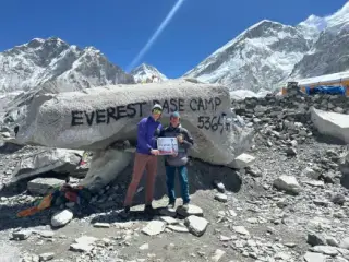
Altitude, not crime, is the real risk on a Nepal trek: Everest Base Camp sits at 5,364 m, Thorong La on the Annapurna Circuit at 5,416 m. Above 3,000 m, gain no more than 300 to 500 m of sleeping altitude a day, build in acclimatisation days, climb high and sleep low, and descend at once on severe headache, vomiting or confusion. Untreated acute mountain sickness progresses to HAPE and HACE, which kill.
As of 30 July 2026 the US State Department rates Nepal Level 2, down from Level 3 in March 2026 after the September 2025 protests ended; the UK FCDO carries no blanket warning. Avoid large urban gatherings and check travel.state.gov before departure. On evacuation cover, see our travel insurance page.
How tall is Mount Everest in 2026?
8,848.86 m (29,031.7 ft), agreed jointly by Nepal and China on 8 December 2020. The 8,848 m figure many sites publish is out of date.
Why is Nepal's time 45 minutes ahead of India?
Nepal adopted a standard meridian near Gaurishankar in 1956, moving from UTC+5:30 to UTC+5:45, and does not observe daylight saving.
Can I use my credit card in Nepal?
Yes in Kathmandu, Pokhara and larger towns; no past the roadhead, where teahouses and porters take cash only.
What is the best month to trek in Nepal?
October and November give the most stable weather and clearest skies, then March to May. If only the monsoon months work, go to Upper Mustang or Dolpo.
Can I fly internationally into Pokhara or Bhairahawa?
Not reliably as of July 2026: Pokhara has had no regular international service since March 2025, and Bhairahawa handled 19,590 international passengers in 2025.
Is Nepal safe to travel in 2026?
Yes on current official advice: the US State Department moved Nepal to Level 2 in March 2026 and the UK FCDO has no blanket warning. See our Nepal destination page.
Checked 30 July 2026. Census data from the National Statistics Office, rates from Nepal Rastra Bank, health guidance from the CDC. Rates, schedules and festival dates change.
Planning a first trip to Nepal?
Tell us your dates and how much time you have. We will suggest routes that suit the season you are travelling in.