A 30-day restricted trek to the North and South base camps of Kanchenjunga (8,586 m), the world's third-highest peak, in far-east Nepal.
Duration
30 Days
Max Altitude
5,143 m / 16,873 ft
Difficulty
Hard
Group Size
Max 7 trekkers
Region
Kanchenjunga Treks, Nepal
Best Season
Spring · Autumn
Accommodation
Basic teahouses; some camping high up
Meals
Dal bhat, Tibetan bread, noodles; 3 meals included
Transport
Flight Kathmandu-Bhadrapur; jeep to Taplejung
Dates & Prices
Choose your date
All dates are guaranteed departures — we never cancel for low numbers. Book online or send a quick enquiry.
YearMonth
3 departures · 2026
Sep
5
Sep 5, 2026 — Oct 4, 2026
Guaranteed departure — from 2 trekkers
Available
USD2,610
per person
Oct
7
Oct 7, 2026 — Nov 5, 2026
Guaranteed departure — from 2 trekkers
Available
USD2,610
per person
Nov
10
Nov 10, 2026 — Dec 9, 2026
Guaranteed departure — from 2 trekkers
Available
USD2,610
per person
Can’t find a suitable date? We run private departures on any date with as few as 2 trekkers.
Trip Overview
About the Kanchenjunga Base Camp Trek
The Kanchenjunga Base Camp Trek is a 30-day restricted-area trek in far-east Nepal, reaching the foot of Kanchenjunga (8,586 m), the world's third-highest mountain and the highest peak straddling the Nepal-India border. The route crosses the Kanchenjunga Conservation Area from the trailhead at Taplejung, climbs through Limbu, Rai and Sherpa villages along the Tamor River and its tributaries to the North Base Camp at Pang Pema (5,143 m), and most itineraries also reach the South Base Camp at Oktang/Ramche (around 4,580 m) via the high Tanbharma traverse.
Access starts with a flight from Kathmandu to Bhadrapur in the Terai, followed by a drive of several hours to Taplejung or Sekathum. From there the trail enters one of Nepal's most remote valleys: Ghunsa (3,427 m), a Sherpa village with a gompa, sits below the dramatic Kangbachen wall; Kambachen and Lhonak (4,780 m) are lonely high-altitude campsites before the final push to Pang Pema. The South Base Camp leg crosses the high ridge south of Ghunsa via Tanbharma Danda (4,641 m) to Cheram and Ramche, with views of the Yalung Glacier.
This is a strenuous, remote trek in a restricted zone. A Kanchenjunga Restricted Area Permit and the Kanchenjunga Conservation Area Permit (KCAP) are mandatory for all trekkers, and a licensed guide and a group of at least two are required by law. Basic teahouses serve most nights, with some camping sections. The trail is one of the longest in Nepal, reaching about 5,143 m at its highest, and altitude acclimatisation, fitness and self-sufficiency are the main demands. The guide sections below cover permits, difficulty, seasons, food and what to pack.
Last updated June 2026
Trip Highlights
Highlights
1
Reach Pang Pema North Base Camp (5,143 m) below Kanchenjunga (8,586 m), the world's third-highest peak
2
Visit the South Base Camp at Oktang/Ramche (~4,580 m) above the Yalung Glacier
3
Cross the high Tanbharma Danda ridge (4,641 m) connecting the two base camp legs
4
Walk through Limbu, Rai and Sherpa villages in one of Nepal's most remote eastern valleys
5
Trek through the Kanchenjunga Conservation Area with red panda, snow leopard habitat and large cardamom farms
6
One of Nepal's longest and least-crowded restricted treks, with views of Kanchenjunga and its satellite peaks
Day by Day
Kanchenjunga Base Camp Trek Itinerary: 29 Days
Tap any day to expand — altitudes, walking times, meals, and overnight details for every stage of the journey.
A Swotah representative meets you at Tribhuvan International Airport and transfers you to your hotel in Thamel. Your lead guide briefs you on the full 30-day route, the restricted-area permit process and the gear requirements for the high camps. This is a good evening to sort your kit, buy any last supplies and confirm your packing list. Overnight in Kathmandu.
Sleep at 1,400 m
Tonight’s stay
Hotel
A guided morning visits Kathmandu Valley's UNESCO World Heritage Sites, typically Pashupatinath temple on the Bagmati River, Boudhanath stupa and one of the Durbar Squares. The afternoon is free for final preparations, currency exchange and picking up snacks for the trail. Swotah finalises the Kanchenjunga Restricted Area Permit and the Kanchenjunga Conservation Area Permit (KCAP) while you explore. Overnight in Kathmandu.
Sleep at 1,400 mBreakfast
Tonight’s stay
Hotel
An early domestic flight (about 45 minutes) carries you from Kathmandu to Bhadrapur in the far-east Terai. A private jeep then winds north through the cardamom-growing hills of Ilam district and up to Suketar (2,420 m), where the Taplejung airstrip sits on a wide ridge with early views of the Kanchenjunga massif on a clear day. The drive takes around 5 hours. Overnight in Suketar / Taplejung.
Sleep at 2,420 mBreakfastLunchDinner
Tonight’s stay
Guesthouse
The trek begins, dropping from Suketar's ridge through subtropical forest and terraced fields into the upper Tamor River valley. The trail descends roughly 880 m over 4 to 5 hours, passing small Limbu and Rai farmsteads where large cardamom plants line the shaded forest floor. Phurumbu (1,542 m) is the first overnight stop, a cluster of stone houses with basic teahouse lodging. Overnight in Phurumbu.
Sleep at 1,542 mBreakfastLunchDinner
Tonight’s stay
Teahouse
The route continues down-valley along the Tamor River, passing Mitlung, crossing suspension bridges over clear Himalayan tributaries and traversing a stretch of forest with large cardamom plantations managed by Limbu families. Chiruwa (1,270 m) is the lowest point of the trek, sitting in a warm river gorge about 5 to 6 hours from Phurumbu. The teahouses here are among the most comfortable on the lower trail. Overnight in Chiruwa.
Sleep at 1,270 mBreakfastLunchDinner
Tonight’s stay
Teahouse
From Chiruwa the trail climbs steadily away from the Tamor and enters the Ghunsa Khola drainage, the main valley leading toward Kanchenjunga. The path passes through Tapethok and crosses the Ghunsa Khola at Sukethum (1,585 m), the first checkpoint where the Kanchenjunga Restricted Area Permit is inspected. The walk of 6 to 7 hours gains and loses height through mixed subtropical forest. Overnight in Sukethum.
Sleep at 1,585 mBreakfastLunchDinner
Tonight’s stay
Teahouse
A sustained climb of roughly 800 m follows the left bank of the Ghunsa Khola upstream through increasingly dense forest. Amjilosa (2,395 m) sits in a clearing at the forest edge with extensive large-cardamom cultivation on the terraced slopes below the village. The trail gains altitude quickly here, and the air begins to cool. About 6 hours of walking. Overnight in Amjilosa.
Sleep at 2,395 mLunchDinner
Tonight’s stay
Teahouse
The trail continues up the Ghunsa Khola valley through temperate oak and rhododendron forest, crossing several side-stream gullies and passing the small settlement of Gyabla (2,730 m). The valley narrows, the forest thickens, and the first glimpses of high ridges appear above the treeline on the northern skyline. About 6 to 7 hours. Overnight in Gyabla.
Sleep at 2,730 mBreakfastLunchDinner
Tonight’s stay
Teahouse
The approach to Ghunsa (3,427 m) follows the Ghunsa Khola through stands of birch and rhododendron, gaining around 700 m over 7 to 8 hours. Ghunsa is the main Sherpa village on the route, with a small gompa, prayer flags and a cluster of stone houses under the shadow of the Kanchenjunga massif. This is the best-serviced stop north of Taplejung, with decent teahouses and limited hot water. An extra night here is sometimes used for acclimatisation. Overnight in Ghunsa.
Sleep at 3,427 mBreakfastLunchDinner
Tonight’s stay
Teahouse
Leaving Ghunsa the trail climbs steeply out of the treeline into high-alpine terrain, crossing boulder fields and lateral moraines with the first close views of Jannu (Kumbhakarna, 7,711 m) to the west. Kambachen (4,050 m) is a small collection of stone shelters and basic lodges set on a moraine terrace, with the Kanchenjunga walls closing in on three sides. About 6 to 7 hours; altitude gain of around 620 m. Overnight in Kambachen.
Sleep at 4,050 mBreakfastLunchDinner
Tonight’s stay
Teahouse
The trail leaves Kambachen and pushes north along the right bank of the glacier, crossing increasingly barren, rocky terrain with only sparse tufts of alpine grass. Lhonak (4,780 m) is a remote flat plateau used as a camping and teahouse stop, with unobstructed views of the north face of Kanchenjunga and Wedge Peak to the east. The altitude gain of 730 m over 6 to 7 hours calls for a slow pace and steady hydration. Overnight in Lhonak.
Sleep at 4,780 mBreakfastLunchDinner
Tonight’s stay
Teahouse
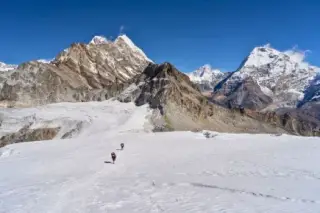
Pang Pema (5,143 m) is the Kanchenjunga North Base Camp and the highest point of the trek. The approach from Lhonak takes 5 to 6 hours over rocky glacial terrain, gaining 363 m on a trail that skirts the Kanchenjunga Glacier. At the base camp, the north and northwest walls of Kanchenjunga (8,586 m) fill the entire horizon: Yalung Kang (8,505 m), Kangbachen (7,903 m) and the Twins ridge are visible from the camp. Time is spent at the base camp before returning to Lhonak, or overnight is taken at Pang Pema where basic facilities allow. Overnight in Lhonak or Pang Pema.
Sleep at 5,143 mBreakfastLunchDinner
Tonight’s stay
Teahouse
The return leg from the North Base Camp area heads back south along the Ghunsa Khola drainage, retracing the route via Lhonak (if not already overnighted there) and down to Kambachen (4,050 m). The descent of around 730 m over 8 to 9 hours is easier on the lungs but harder on the knees; trekking poles are useful on the rocky moraine. The views of Jannu are now seen from the south, a different and equally dramatic perspective. Overnight in Kambachen.
Sleep at 4,050 mBreakfastLunchDinner
Tonight’s stay
Teahouse
A shorter day descends 620 m back to Ghunsa (3,427 m) through the alpine meadows and birch forest, returning to the only proper village on this section of the valley. This is a strategic rest stop before the demanding Tanbharma Danda traverse: the guide will review the next two days' route and conditions. Ghunsa's gompa is worth a second visit in the afternoon if time allows. About 4 to 5 hours. Overnight in Ghunsa.
Sleep at 3,427 mBreakfastLunchDinner
Tonight’s stay
Teahouse
The Tanbharma Danda is the high ridge connecting the North and South base camp legs, and reaching it from Ghunsa involves a climb of more than 1,200 m over 6 to 7 hours. The trail leaves the Ghunsa Khola valley and switchbacks steeply up through rhododendron and then alpine scrub to the open ridge crest at 4,641 m. The panorama from Tanbharma takes in the south and west faces of Kanchenjunga and the full sweep of ridges toward the Yalung Glacier basin. This is a demanding, high-altitude day and a key acclimatisation test. Overnight at Tanbharma Danda camp.
Sleep at 4,641 mBreakfastLunchDinner
Tonight’s stay
Teahouse
From the Tanbharma Danda, the trail drops south and west into the upper Simbua Khola drainage, descending around 770 m over 7 to 8 hours to Cheram (3,870 m). The route passes through high alpine meadows used as yak pasture in summer, with views of the Yalung Glacier below and the south ridges of Kanchenjunga above. Cheram is a small camp / teahouse stop with basic facilities. Overnight in Cheram.
Sleep at 3,870 mBreakfastLunchDinner
Tonight’s stay
Teahouse
A short but steep climb of around 710 m leads to Ramche (also called Oktang, approximately 4,580 m), the South Base Camp area of Kanchenjunga. The walk takes 3 to 4 hours, gaining altitude steadily through moraines and boulder fields above the Yalung Glacier. From Ramche, the southwest face of Kanchenjunga (8,586 m) is fully visible, as are the twin summits of Kanchenjunga South (8,476 m) and the Talung face. The afternoon allows exploration and acclimatisation at altitude. Overnight in Ramche.
Sleep at 4,580 mBreakfastLunchDinner
Tonight’s stay
Teahouse
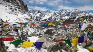
A full rest day at Ramche (4,580 m) serves both acclimatisation and exploration. Morning light on the southwest face of Kanchenjunga is one of the most dramatic mountain views in Nepal, with the 8,586 m summit pyramid directly above and the Yalung Glacier filling the valley floor below. Trekkers can walk to the Oktang viewpoint chortens above Ramche, which at around 4,600 m give the closest open view of the South Face. Rest, hydrate and prepare for the Yalung Base Camp excursion the following day. Overnight in Ramche.
Sleep at 4,580 mBreakfastLunchDinner
Tonight’s stay
Teahouse
The Yalung Glacier Base Camp at around 4,500 m lies below the Yalung icefall on the southwest flank of Kanchenjunga. The excursion from Ramche takes 4 to 5 hours return, crossing moraine and glacier margins to reach a closer perspective on the hanging seracs and the South Face. This is the approach used by expeditions attempting the Yalung Face route, first climbed in 1955 by the British team of Charles Evans. Return to Ramche by afternoon. Overnight in Ramche.
Sleep at 4,500 mBreakfastLunchDinner
Tonight’s stay
Teahouse
The descent from Ramche heads south into the Simbua Khola valley, dropping more than 1,500 m over 5 to 6 hours through high-alpine meadows and then mixed forest to Torong (2,995 m) near Tseram. The trail is well-marked but steep in places. After the days above 4,500 m, the warmer temperature and thicker air of the lower valley are welcome, and the vegetation changes sharply from bare moraine to juniper, birch and, lower down, rhododendron. Overnight in Torong.
Sleep at 2,995 mBreakfastLunchDinner
Tonight’s stay
Teahouse
From Torong the trail climbs back up to the Lasiya Bhanjyang pass (3,310 m), a ridge saddle on the exit route toward Yamphudin. The 6-hour day involves a re-ascent of around 315 m followed by a descent on the far side, through oak and rhododendron forest on the southern slopes. Clear days offer views back toward the Kanchenjunga massif on the northern skyline. Overnight at Lasiya Bhanjyang.
Sleep at 3,310 mBreakfastLunchDinner
Tonight’s stay
Teahouse
A steady descent of 1,230 m over 5 hours leads to Yamphudin (2,080 m), a sizeable Rai village with better teahouse facilities than the upper camps. Yamphudin marks the transition back to the inhabited Tamor valley world, with terraced fields of millet and maize, and children walking to school on the lower trail. This is a good place to pick up fresh fruit and local snacks unavailable since Taplejung. Overnight in Yamphudin.
Sleep at 2,080 mBreakfastLunchDinner
Tonight’s stay
Teahouse
A long day on the lower exit trail covers varied terrain including ridge crests, river crossings and forested sections, descending to the Tamor valley floor and climbing again to Phumphe Danda (1,858 m). About 7 to 8 hours of walking. The lower valleys here show the full range of Limbu settlement, from terraced farmhouses with bamboo fencing to small chautaras (stone resting platforms) under spreading pipal trees along the trail. Overnight in Phumphe Danda.
Sleep at 1,858 mBreakfastLunchDinner
Tonight’s stay
Teahouse
The trail continues south through a series of ridge saddles and valley crossings, gaining and losing height through Rai and Limbu villages on the lower Taplejung trail. Kande Bhanjyang (2,129 m) is a pass-top settlement with views west over the cultivated hills of Taplejung district. About 6 to 7 hours of walking. The lower villages here are far more densely farmed than the Kanchenjunga Conservation Area above. Overnight in Kande Bhanjyang.
Sleep at 2,129 mBreakfastLunchDinner
Tonight’s stay
Teahouse
A long penultimate day on the trail, moving through terraced farmland and mixed forest with views of lower Taplejung district, reaches Lalikharka (2,265 m) after 7 to 8 hours. The trail crosses several stream valleys with suspension bridges and passes through small bazaars where trekkers can buy cold drinks and basic supplies. Altitude is no longer a concern, but the day is long and tiring after 20-plus days on the mountain. Overnight in Lalikharka.
Sleep at 2,265 mBreakfastLunchDinner
Tonight’s stay
Teahouse
The final trekking day climbs back up to the Suketar / Taplejung ridge (2,420 m), completing the circuit of the Kanchenjunga Conservation Area. About 6 hours of walking brings you to the ridge town of Taplejung, where the trek started on day 3. A celebration meal at a local teahouse, a hot shower and a comfortable bed after 23 days on the trail are well deserved. Overnight in Suketar / Taplejung.
Sleep at 2,420 mBreakfastLunchDinner
Tonight’s stay
Guesthouse
A jeep retraces the approach road south through the Ilam hills to Bhadrapur (approximately 100 m) in the Terai, about 5 hours by private vehicle. The drive passes the cardamom and tea-growing belt of Ilam, one of Nepal's best-known tea regions. Bhadrapur is a flat, warm town, a contrast with the cold high camps of the previous weeks. Overnight in Bhadrapur.
Sleep at 100 mBreakfastLunchDinner
Tonight’s stay
Guesthouse
A morning domestic flight (about 45 minutes) returns you to Kathmandu from Bhadrapur. The rest of the day is free: a final dinner, souvenir shopping in Thamel or a massage after 30 days on the trail. A Swotah representative is available to help with any last-day arrangements, extensions or onward travel. Overnight in Kathmandu.
Sleep at 1,400 mBreakfast
Tonight’s stay
Hotel
Your Kanchenjunga Base Camp trek ends today. A Swotah representative transfers you to Tribhuvan International Airport for your onward flight. If you would like to extend your stay in Nepal, add a Chitwan safari, a Pokhara extension or another trek, we are glad to arrange it.
Breakfast
What’s included
What's included
Every cost on the trail is broken out below — no hidden fees, no surprises at the trailhead.
Included
10 items
Airport transfers;
Standard/Deluxe room in Kathmandu on twin/double sharing with breakfast;
Guided sightseeing tour in Kathmandu on a private vehicle;
Accommodation during the trek (or camping in case of need);
All meals (breakfast, lunch, dinner with one drink along) during the trek;
Authorized English-speaking guide along with porters (2:1);
All applicable government tax;
All expenses for all staff: meals, accommodation, salary, equipment, insurance, transportation;
All necessary paperwork and Kanchenjunga Special Trekking Permit, Trekkers' Information Management System fees (TIMS);
Medical kit;
Not included
8 items
International flights, Nepalese visa fee;
Excess baggage charge(s) for the domestic flight;
Extra night accommodation in Kathmandu and Pokhara because of early arrival, late departure, or early return from the mountain due to any reason other than the scheduled itinerary;
Lunch and evening meals in Kathmandu;
Entrance fees during sightseeing;
Travel and rescue insurance;
Personal expenses (phone calls, laundry, bar bills, battery recharge, extra porters, bottle or boiled water, shower, etc.);
Tips for guide(s), porter(s) and driver(s).
How Hard Is the Kanchenjunga Base Camp Trek?
The Kanchenjunga Base Camp Trek is a strenuous, remote trek with no technical climbing. It reaches 5,143 m at Pang Pema and includes several nights above 4,000 m, long ridge days and basic accommodation, so altitude acclimatisation, good fitness and self-sufficiency are essential.
▲Strenuous and remote. 5-9 hr days, max 5,143 m (Pang Pema). No technical climbing; good fitness, acclimatisation days and a health check required.
Overall Rating
6
Hard
out of 10 · physical effort scale
Max altitude5,143 m
Trekking days26 days
Trip Details
Kanchenjunga Base Camp Trek: Permits, Food, Accommodation & Safety
In-depth guides on accommodation, food, permits, insurance and special considerations — tap any topic to expand.
The Kanchenjunga Base Camp Trek is graded strenuous, and altitude is the primary factor. The route reaches Pang Pema North Base Camp at 5,143 m, with several nights above 4,000 m at Kambachen (4,050 m), Lhonak (4,780 m) and Ramche (4,580 m). Acute mountain sickness (AMS) is a real risk at these elevations, and the itinerary builds in acclimatisation time at Kambachen and Ghunsa before the push to Pang Pema.
Trail days run 5 to 9 hours on rough, remote paths with significant elevation gain and loss, especially on the Tanbharma Danda traverse (4,641 m) between the North and South base camp legs. There is no technical climbing required, but the valley is isolated, resupply is limited, and rescue can be slow. Swotah guides carry a first-aid kit and a pulse oximeter. Anyone with a respiratory or heart condition should see a doctor before booking, drink 3 to 4 litres of water daily, and report any AMS symptoms to the guide at once.
Autumn (late September to November) and spring (March to May) are the two reliable seasons for the Kanchenjunga Base Camp Trek. Autumn gives the clearest skies after the monsoon, stable high-altitude weather and good views of Kanchenjunga and the Yalung Glacier. Spring is warmer in the lower valleys, with rhododendron in flower below 3,500 m, though late-season snow can remain on the Tanbharma Danda ridge in March.
Winter (December to February) is cold and harsh above 4,000 m; the high ridge and both base camp approaches can be snow-covered, and some teahouses close. The summer monsoon (June to August) brings heavy rain on the lower Tamor valley trail, leeches and some landslide risk, though the eastern rain shadow is less severe than on the Nepal ranges further west. The monthly weather cards above show the temperature and conditions picture.
The Kanchenjunga trek requires two main permits. The Kanchenjunga Restricted Area Permit costs approximately USD 20 per person per week (flag: fee subject to change; verify before booking), and is issued only to guided groups of at least two trekkers booked through a registered agency. The Kanchenjunga Conservation Area Permit (KCAP) is additionally required for all trekkers entering the conservation area.
Because the trek is in a restricted zone, independent trekking is not permitted: a licensed guide must accompany the group throughout. Swotah handles all permit paperwork once you provide a passport copy and photos, and confirms current fees before your departure. Carry the permits at all times, as checkpoints are set at several points along the trail from Taplejung onward. A TIMS card (Trekkers Information Management System) may also be required depending on current regulations.
Accommodation on the Kanchenjunga trek is mainly basic teahouses, simpler than on the Everest or Annapurna circuits because the region is remote and receives far fewer trekkers. Ghunsa (3,427 m) has the best lodges on the route, with reasonable food menus and limited hot water. Kambachen and Lhonak are small and basic, with shared, cold facilities.
Above Lhonak toward Pang Pema, and on sections of the Tanbharma ridge and Ramche approach, camping may be necessary, so the trip carries tents and camping gear for those nights. A four-season sleeping bag is important for the cold nights above 4,000 m, where temperatures drop well below freezing. Kathmandu hotels at the start and finish are comfortable. Teahouses at Yamphudin and lower-route stops are simple but adequate.
Food on the Kanchenjunga trek follows the teahouse pattern: dal bhat (rice, lentil soup and vegetable curry) is the staple and a reliable energy source for long days, served with unlimited refills at most lodges. The menu broadens to noodles, Tibetan bread, eggs, potatoes and momos in the larger villages like Ghunsa, and narrows to dal bhat and basic soups in the high camps at Kambachen and Lhonak.
Swotah includes three meals a day throughout the trek. For water, drink 3 to 4 litres a day to reduce the risk of altitude sickness. Treat or purify all water: lodges sell boiled water, and a filter, UV pen or purification tablets work well; do not drink untreated stream water above Taplejung. Carry a reusable bottle and expect very limited resupply points beyond Ghunsa, so buy snacks and any extra food in Kathmandu or at Taplejung market.
The Kanchenjunga trek begins with a 45-minute flight from Kathmandu to Bhadrapur in the far-east Terai, the closest airport to the trail, followed by a long road drive of around 5 to 7 hours by jeep through Ilam and Taplejung to the trailhead at Suketar or Sekathum. The drive covers hilly roads that can be slow and rough.
At the end of the trek, the exit is also via Suketar and the drive back to Bhadrapur, where the flight returns to Kathmandu. Domestic flights are operated by several airlines including Buddha Air and Yeti Airlines; Swotah books these on your behalf. Bhadrapur airport is subject to weather delays, so allow a buffer day in Kathmandu at the end of the trip for any rescheduling. Swotah runs all road transfers by private jeep.
Kanchenjunga (8,586 m) is the third-highest mountain in the world and is considered sacred by both the Sikkimese and the Nepali communities of the Kanchenjunga region. By tradition, no climber steps on the true summit: expeditions stop just below the top out of respect, a custom observed since the first ascent by a British team in 1955.
The lower valleys of the trek pass through the homeland of the Limbu and Rai peoples, two of Nepal's Kirat ethnic groups with their own Kirant script, oral poetry and animist-Hindu traditions. Taplejung and Phungling are Limbu market towns. Higher up, Ghunsa is a Sherpa village with a gompa and prayer flags, culturally related to the Tibetan Buddhist communities of Solu-Khumbu. Cardamom cultivation is widespread at mid-altitude, and the large cardamom farms around Sukethum and Amjilosa are a distinctive feature of the lower trail.
A licensed guide is legally required on the Kanchenjunga trek, and is also practically essential given the remoteness of the valley, the altitude involved and the multiple permit checkpoints. Swotah's guides hold Ministry of Tourism licences, Nepal Mountaineering Association training and know the route including the Tanbharma Danda traverse and the two base camp approaches. Guides also carry a first-aid kit and a pulse oximeter to monitor the group.
A porter is strongly recommended for this long, high-altitude trek: one porter carries 20 to 25 kg, and we cap loads at that weight. Swotah provides a free duffel for porter loads, so you carry a light daypack and a warm layer. Porter and guide welfare (insurance, fair pay, adequate gear) is part of Swotah's operating standard in a region where many seasonal workers rely on trekking income.
Mobile coverage on the Kanchenjunga trek is limited. Nepal Telecom (NTC) gives the best signal in Taplejung and the lower villages, with patchy reception in Ghunsa and near-zero coverage above Kambachen and toward Pang Pema. Swotah provides a tourist SIM, but plan to be largely off-grid above Ghunsa for several days at a time.
Wi-Fi is available at a handful of lodges in Taplejung and Ghunsa for a modest fee, but not reliably above that. Charging at teahouses costs a few rupees per device, and availability drops with altitude. A power bank with at least 20,000 mAh is highly recommended; a small solar panel is useful for the camping sections. Cold temperatures above 4,500 m drain lithium batteries overnight, so keep electronics inside your sleeping bag.
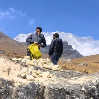
The Kanchenjunga Conservation Area is one of Nepal's most intact mountain ecosystems, home to snow leopard, red panda and Himalayan black bear. 500 m of altitude separation means the lower forests carry a different ecological profile from the high ridge. Carry a reusable water bottle, pack out all non-biodegradable waste, do not cut firewood and avoid single-use plastics, which are a growing problem even in remote trailhead villages.
Respect local customs in Limbu, Rai and Sherpa communities: ask before photographing people or gompa interiors, walk clockwise around mani walls and chortens, and follow your guide's advice at monasteries. Tipping is customary at the end of the trek: a common guideline is 10 to 15% of the trip cost shared among the guide, porter and driver. Tips go directly to workers in a region with limited off-season income, and booking through a registered operator like Swotah ensures permits, insurance and fair loads are handled properly.
What to pack
What to pack
The full kit list. Anything we loan (sleeping bag, down jacket) is called out — bring everything else.
✓Duffel bag (carried by porter)
✓Daypack (25-30L)
✓Dry bag or rain cover
✓Packing cubes
Frequently Asked
Questions & Answers
Everything trekkers ask before booking. Don't see yours? Tap Enquire — we usually reply within a few hours.
Yes, our representative will be there to greet you at the airport. Upon arrival, you will be transferred to your hotel by a private car/jeep.
Yes, there is going to be a small orientation/briefing program before we embark on our adventure by the tour manager, leader/guide.
For nights in cities, we use standard/superior standard/deluxe rooms whereas, during the trek we use lodges/tea houses/guesthouses/campingfor our clients, and whatever is available and accessible. We also arrange sleeping bags for our clients, on their request.
We believe in operating small intimate group to provide personal attention and services to our guests. Small groups can enjoy the trek hassle free and enjoy the customized trip according to their need and suitability. We do not incorporate more than 14 People in a group, unless we get special requests from our clients.
To confirm your booking, a deposit of 15% of total trip amount is required if you are booking at least a year in advance before trip departure date. If booking is made between 100-364 days before the trip departure, you'll need to pay 20% to confirm the trip. If payment is made between 99-60 days, 25% of the total trip amount will need to be paid and if booked between 59-30 days, 50% of the total trip amount needs to be paid and finally, if you are booking 29 days prior to trip departure, then 100% payment should be made. The payments can be easily made by the bank transfer. The due balance is payable on arrival in Kathmandu with cash (preferably USD/EURO) or card on POS/credit card machine. Please note that non refundable fee is 10% or $200 whichever is greater.
We customize the trip according to your preference but if you need to change plan during the trek, consult the guide.
If you need extra day to complete the trekking, you'll need to inform the guide in advance and the guide will let the company know. Adding a day to trekking can result in many changes in other arrangements such as transportation, guides' schedule, flight details, hotel bookings and all, so we really don't recommend this to our clients unless there's an emergency cases. But it's true that those changes could be made but it will cost extra. The best way to do it is to inform the agent company about it.
Kanchenjunga Base Camp is the remotest trek in Nepal but still provides wide range of delicious western meals like Pasta, noodles, pizzas, bread, soup etc. Dal Bhat (Rice, Lentils and Vegetables) are great way to gain energy for the strenuous trek. As you trek higher, you should avoid meat for health purpose as it is not good to eat meat in higher altitude and also the meat is not very fresh.
There are plenty of water stations on each stop on the route. You can easily fill up the bottle from the open taps. We recommend that you bring water purifier tablets with you or at least get it from Kathmandu before you depart for trekking. You can also buy mineral waters but we usually recommend tap water which is pure and it helps us not promoting plastic bottled water.
We use private car/jeep/van depending on the size of the group for sightseeing inside the Kathmandu Valley and transfer to Birtamod on domestic flight.
We contact the lodge/guesthouse owner for reservation of the room before trekking on a particular day, on other days porters reach to the destination on advance and book the rooms for you.
While trekking in higher lands, you need to pay for charging the electronics upon request to the owner. The best idea always is to bring your own power bank with you. It's easier and cheaper.
Whilst trekking in eastern region, you can make local and international calls from telephone provided by the guesthouse/teahouse owner after paying certain amount directly.
Usually, we have to walk about 7-9 hours a day. But it should not be taken as certain thing because the hours of walk depends on client’s speed. So it is really relative.
Trekking is a tiresome activity that requires a lot of physical movement so pack your active wears and trekking pants for at lower altitudes. Weather at high altitude is unpredictable so carry a light weight waterproof jacket along with thick down jacket, pant and thermal innerwear t to escape severe cold. Needless to say that, good shoes are very important for trekking in rough and snowy terrain, so invest on good quality shoes or rent it from us in a minimum price. As you are trekking in remote village, try to wear modest clothes to quickly gel up with the local people without hesitation.
You have to carry your personal bags with water bottle and medicines remaining bags will be carried by porters to make you easy to trek. The weight limit for porters is 15 KG.
Yes, Nepal can boast as one of the safest country in South Asia for women, you will find people very friendly and respectful towards foreigners especially towards women. Kanchenjunga Base Camp is one of the most visited areas by the tourists so the service providers are professional and local people are respectful with welcoming hospitality towards the trekkers.
We make sure to take security measures during trek to make your trip delightful. We hire experienced and license holding guides to safeguard your life in mountains. We suggest you to follow the guide’s instruction carefully and take responsibility for personal belongings. Always keep your valued belongings near you and lock the door from inside during the night.
Kanchenjunga Base Camp can be trekked all year around excluding monsoon season and winters. February to May and Mid-September to November are the best time to do this trek. In winter, it is difficult to trek in snow and harsh weather.
Before coming to Nepal, make sure that you are covered by insurance for about 5500 meters. In case of emergency like altitude sickness, dehydration or any medical condition ask your tour leader to contact us ASAP so that we can manage helicopter for the rescue. You then will be transferred to hospital for the treatment.
All our guides are trekking experts holding license from Nepal Tourism Board, Nepal Government. They are the most valuable assets of the company. Guides know the trekking route like the back of their hand and use their expertise in ensuring your safety in the mountains.
Before coming to Nepal, make sure you are covered for diphtheria & TB, hepatitis A, hepatitis B, malaria, typhoid, polio and tetanus. Make sure you are in best shape to complete the trekking without any complication.
No, you cannot use the credit card during the trek. You have to withdraw the money before you start the trek. You can use credit card only in Kathmandu.
Why Travel with Swotah
Why Book the Kanchenjunga Base Camp Trek with Swotah
Most Nepal operators look the same from the outside. Here's what actually makes the difference.
Born in Nepal
100% locally owned since 2016. Trek profits stay with the mountain families and village schools along your route.
Guaranteed Departures
Every date on our calendar runs — no minimum group size. You never pay to be cancelled.
Certified Guides
Government-licensed, WFR-certified, English-speaking. Most were born within two valleys of the trail.
Small Groups
Small groups, never more than 8 trekkers. You get a real experience, not a convoy.
Gear Included
Sleeping bag and down jacket loaned at no extra charge — both rated to –20°C.
Flexible Payment
Deposit from 10% to confirm, balance before departure or in cash on arrival. Reschedule up to 30 days prior.
24/7 Support
Kathmandu office and dedicated WhatsApp emergency line. We answer at 2am if needed.
Hall of Fame
TripAdvisor Travelers' Choice 2023, 2024 and 2025. Hundreds of verified five-star reviews.
Get a free personalised travel brief for the Kanchenjunga Base Camp Trek.
Tell us your travel dates and group size. Our team in Kathmandu will put together a tailored itinerary, honest costs, and practical tips — completely free, no commitment.