Circle the world’s eighth-highest mountain on a 14-day restricted-area circuit, crossing Larkya La at 5,106 m through one of Nepal’s least-crowded high-altitude corridors.
Duration
14 Days
Max Altitude
5,106 m / 16,752 ft
Difficulty
Hard
Group Size
Max 8 trekkers
Region
Manaslu Trekking Packages, Nepal
Best Season
Spring · Autumn
Accommodation
Teahouse lodges throughout; basic and cold at Dharamsala (4,460 m).
Meals
All meals on trek: dal bhat, Tibetan bread, noodles, yak dishes. Limited choice above Samagaon.
Transport
Jeep Kathmandu–Arughat Bazaar (7–8 hrs); jeep out via Dharapani–Besisahar.
Dates & Prices
Choose your date
All dates are guaranteed departures — we never cancel for low numbers. Book online or send a quick enquiry.
YearMonth
11 departures · 2026
Aug
3
Aug 3, 2026 — Aug 16, 2026
Guaranteed departure — from 2 trekkers
Available
USD1,275
per person
Aug
17
Aug 17, 2026 — Aug 30, 2026
Guaranteed departure — from 2 trekkers
Available
USD1,275
per person
Aug
31
Aug 31, 2026 — Sep 13, 2026
Guaranteed departure — from 2 trekkers
Available
USD1,300
per person
Sep
14
Sep 14, 2026 — Sep 27, 2026
Guaranteed departure — from 2 trekkers
Available
USD1,275
per person
Sep
28
Sep 28, 2026 — Oct 11, 2026
Guaranteed departure — from 2 trekkers
Available
USD1,275
per person
Can’t find a suitable date? We run private departures on any date with as few as 2 trekkers.
Trip Overview
About the Manaslu Circuit Trek
The Manaslu Circuit Trek is a 14-day teahouse trek in the Gorkha district of central Nepal that circumnavigates Manaslu (8,163 m / 26,781 ft), the world's eighth-highest mountain, and crosses the Larkya La pass at 5,106 m (16,752 ft). Because the route passes through a restricted area requiring a special permit in addition to standard trekking documents, visitor numbers are far lower than on the adjacent Annapurna routes. In a month when 8,000 trekkers walk the Annapurna Circuit, the Manaslu Circuit sees fewer than 1,000.
The name Manaslu derives from the Sanskrit word "Manas," meaning intellect or soul. The circuit begins at Machhakhola (870 m) and climbs for eight days through a striking sequence of landscapes: subtropical riverine forest, terraced Gurung farmland, pine and juniper highland, Tibetan high-altitude plateau, and glaciated alpine terrain above Dharamsala. From Namrung upward, the villages belong to the Nubri Tibetan Buddhist communities whose language, dress, and traditions remain largely intact.
Larkya La is the high point and the reason the trek demands serious preparation. The crossing is done as a 13–14 hour day from Dharamsala (4,460 m), gaining 646 m to the pass then descending 1,516 m to Bimthang (3,590 m) on the far side. Most groups leave at 3–4 am with headlamps to reach the pass before the afternoon cloud builds. Mount Manaslu was first summited on May 9, 1956, by Japanese mountaineers Toshio Imanishi and Gyalzen Norbu.
Last updated June 2026
Trip Highlights
Highlights
1
Cross Larkya La at 5,106 m: the circuit’s defining moment
2
A complete circumnavigation of an 8,000 m peak
3
Tibetan Buddhist Nubri culture in the upper valley
4
Low visitor numbers on a high-altitude route
5
Five distinct landscape bands in one trek
6
The Budhi Gandaki gorge
Day by Day
Manaslu Circuit Trek Itinerary: 14 Days
Tap any day to expand — altitudes, walking times, meals, and overnight details for every stage of the journey.
KATHMANDU ARRIVAL: Upon landing at Tribhuvan International Airport, Kathmandu, you will be warmly welcomed by our staff members and escorted in our private car to your chosen hotel. A briefing about the trek, along with navigation supplies such as maps, will be either conducted in our car or at the hotel where you will be staying.
A city built on thousands of fulfilled and unfulfilled dreams, Kathmandu is a place of polarizing contrasts. You can have the most updated technology in the world, but it is most likely going to be housed in a century-old building—adorned with cracks all over and dangling wires across.
Sleep at 1,400 m
Tonight’s stay
Hotel
KATHMANDU TO MACHHAKHOLA (870M): We leave Kathmandu at first light and commence our trip. As we drive out of the Kathmandu Valley, the landscape switches from concrete chaos embracing the serene rolling hills of the Himalayan foothills, where terraced fields and steep slopes cascade down.
Tracing the roaring Trishuli River below, we move ahead in the companionship of nature. Crossing suspension bridges that gently sway with a gentle breeze. Passing through a series of tiny rustic villages like Dhading Besi and Arughat on the way that portrays the simplicity of rural life, and Soti Khola in Gorkha. Going ahead, waterfalls tumble down the moss-covered cliff and murmur with the fierce river, Budi Gandaki. The deep gorges take up to 10-11 hours to reach our destination for the day, Machhakhola. At an elevation of 870 meters (2,854 feet) above sea level, this is the crucial stop for trekkers on the Manaslu trail.
Sleep at 870 mBreakfastLunchDinner
Tonight’s stay
Guesthouse
MACHHAKHOLA TO JAGAT (1440M): The distance from Machhakhola to Jagat takes around 8-10 hours to complete, covering a distance of approximately 22 km (13.7 miles). Following the Budi Gandaki River, crossing through several suspension bridges and small terraced villages. There are many key stops on the way. Passing through Khorlabesi. We reach Tatopani, which means “hot water “ in Nepali, a place known for its natural hot spring, which is excellent for unwinding and relaxation. A major attraction for inquisitive tourists. Leaving it behind, we traverse through Dovan and Yaru along the way, the final stretch to Jagat. It is an entry point to the Manaslu Circuit trek, where trekkers must register their permits.
22.0 km~9.0 h walkingSleep at 1,440 mBreakfastLunchDinner
Tonight’s stay
Guesthouse
JAGAT TO DENG (1860M): Starting the trek from Jagat at the elevation of 1,440 m, we move forward toward our destination for the day, Deng, which will cover approximately 20 kilometres (12.4 miles). This trek takes about 7-8 hours, depending on the pace of your hiking. Along the trail, we cross several bridges over our constant companion, the Budi Gandaki River, and pass through small settlements such as Salleri, Sirdibas and Philim, which serve as stops for lunch, each carrying their own stories to express. Ascending and Descending in a sweeping landscape, with the Manaslu Massif visible in the distance, if you're lucky enough. Buddhism is deeply rooted in this region; Philim Gompa and Deng Gompa can also be seen along the trail.
20.0 km~7.5 h walkingSleep at 1,860 mBreakfastLunchDinner
Tonight’s stay
Guesthouse
DENG TO NAMRUNG (2630M): The gradual ascent of the trail takes us through a lush green forest filled with rhododendrons, pine trees, and bamboo, which provides a habitat for a variety of flora and fauna. Numerous waterfalls cascade down the cliff, serving as a picturesque environment for the trekkers. The hike takes typically 7-8 hours and covers 19 kilometres (11.8 miles). The clear transition from the temperate to the Alpine zone is visible, and the climate is felt upon reaching the destination for the day, Namrung(2,630 meters). The tree starts to thin, with more shrubs, alpine meadows and hardy grass. The scenic overlooks of Ganesh and Siringi Himal ranges are visible from Namrung, the major checkpoint on the Manaslu Circuit. Also, the trek further ascends into the Upper Nubri valley.
19.0 km~7.5 h walkingSleep at 2,630 mBreakfastLunchDinner
Tonight’s stay
Guesthouse
NAMRUNG TO SYALA (3500M): Throughout the trek, villages are adorned with intricate and serene Buddhist architecture. Mani walls ( stone walls with carving) are believed to bring luck with each rotation. Chortens ( stupas) are sacred structures and embodiments of the spiritual journey of the Himalayan people. There is a noticeable shift in culture and a more prominent influence of Tibetan Buddhism along the trek. The trail ascends through lush forests and picturesque villages like Lihi and Sho, offering dramatic views, with the majestic Mount Manaslu dominating the skyline. Trek to Lho village offers you mountain vistas of Himal Chuli, Ngadi Chuli, Ganesh Himal, Siring Himal, Naike Peak, and Larke Peak. Along with the significant Ribung Gompa monastery, the final stretch to Syala at 3,500 meters covers approximately 8 kilometres ( about 5 miles) and takes 5-6 hours of hike.
8.0 km~5.5 h walkingSleep at 3,500 mBreakfastLunchDinner
Tonight’s stay
Guesthouse
SYALA TO SAMAGAON (3530M): A leisurely, short, flat walk from Syala (3,500 meters/11,483 feet) to Samagaon (3,530 meters/11,581 feet) takes about 3-4 hours of trekking. This relatively short hike helps to acclimatize your body to the surroundings. The day can be used to take a closer glimpse into the locals' way of living and immerse yourself in their culture and lifestyle. The villages of Syala and Samagaon themselves are integral parts of the landscapes. Tranquil and soothing glacial rivers, small waterfalls, green and rocky landscapes and some of the best views of the towering peak Mount Manaslu, along with other notable peaks, including Himal Chuli, Ngadi Chuli ( Peak 29) and Siring Himal, leave trekkers in constant awe and inspiration. Trekkers mostly visit Pungyen Gompa and Sama Gompa, also known as Kagyu Chholing , a central spiritual hub, carrying prayers and faith in each brick of the monastery. Samagaon is also the base for two classic acclimatisation side-trips — the glacial Birendra Lake (3,450 m / 11,319 ft, a 3–4 hour return walk) and Manaslu Base Camp (4,800 m, a 6–7 hour round trip). On the standard 14-day pace the afternoon allows the shorter Birendra Lake walk; both fit comfortably if you add the optional extra night at Samagaon (see FAQs).
~3.5 h walkingSleep at 3,530 mBreakfastLunchDinner
Tonight’s stay
Guesthouse
SAMAGAON TO SAMDO (3875M): Leaving Samagaon behind, we head north to Samdo (3,875 m / 12,713 ft), a small, remote Tibetan village just a few kilometres from the Tibetan border and the last settlement before the Larkya La. The trail follows a gradual ascent of about 4–5 hours along the Budi Gandaki. En route you pass alpine meadows where, with luck, you may spot grazing yaks, blue sheep and Himalayan thar. As you approach Samdo the landscape turns rugged and barren, underscoring the remoteness of the region. Samdo rewards you with warm hospitality, Buddhist artefacts and shrines, and superb views of Manaslu — a fitting last stop before the pass.
~4.5 h walkingSleep at 3,875 mBreakfastLunchDinner
Tonight’s stay
Guesthouse
SAMDO TO DHARAMSALA (LARKE PHEDI) (4460M): The ninth day of the trek is a significant segment of the Manaslu Circuit trek , and the challenging part of the trek begins at the crack of dawn. The trek starts with an initial descent from the Samdo and gradually ascends, passing through Larkya Bazaar, a seasonal market where Tibetan traders once exchanged goods with Local Nepalese.
Trekkers are treated with the panoramic views of Mount Manaslu, Himalchuli, Ngadi Chuli, Simnang Himal, Larkya Peak, Cheo Himal and Kang Guru, alongside the rugged terrain and sparse vegetation. Continuing along the trail towards Dharamsala (4,460 meters / 14,632 feet), also known as Larkya Phedi, trekkers reach the base camp for Larkya La Pass.
This covers approximately 8-10 kilometres and around 6-7 hours, depending on oneself. The weather at Dharamsala is harsh and unpredictable, with mostly cold temperatures, strong winds and snowfall. Accommodation here is basic, with a few teahouses offering dormitory-styled rooms and a communal toilet. Due to a limited number of accommodations, some trekkers also opt for camping in Dharamsala. Take as much rest and prepare yourself for the strenuous climb over Larkya La Pass ahead.
9.0 km~6.5 h walkingSleep at 4,460 mBreakfastLunchDinner
Tonight’s stay
Guesthouse
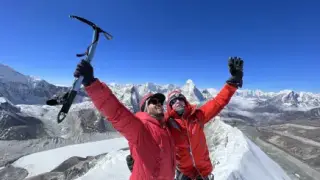
DHARAMSALA TO BIMTHANG (3590M): The trail from Dharamsala (Larke Phedi) to Bimthang is a significant and most challenging section of the Manaslu Circuit Trek. It involves crossing the highest point of elevation, Larkya La Pass (5,106 meters / 16,752 feet). The trail to Larkya La pass is demanding, with a rocky ascent and uneven path covered in ice, snow, and moraine debris. Careful footing is required, as it can get slippery.
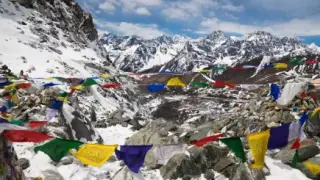
Upon reaching the Larkya Pass, trekkers will enjoy spectacular 360-degree views of the towering peaks, including Mount Manaslu, Himalchuli, Kang Guru, Cheo Himal, Larkya Peak, Simnang Himal, and Annapurna II. The peaks rise dramatically against the clear blue sky, creating a breathtaking panorama.
After crossing Larkya La pass, the descent to Bimthang reveals a clear transition in the surrounding environment. The landscape changes to high-altitude desert areas with sparse vegetation and hardy shrubs and passes through rhododendron forests dotted with red, pink and white flowers, as well as lush pine forests. This creates a striking contrast to the barren high-altitude terrain and gentle meadows.
Bimthang, situated at an elevation of 3,590 meters (11,778 feet), marks the end of this challenging section. The trek from Dharamsala to Bimthang takes approximately 13–14 hours and covers 24 kilometres ( 15 miles).
24.0 km~13.5 h walkingSleep at 3,590 mBreakfastLunchDinner
Tonight’s stay
Guesthouse
BIMTHANG TO TILJE (2300M): The descent from Bimthang is gentle compared to the ascent of Larkya La Pass. It offers the stupendous views of the Mount Manaslu, Manang, and Himlung Himal ranges. The well-defined trail passes through dense pine and rhododendron forests, crossing several small rivers via bridges. Trekkers will pass through small villages of the Karche, home to the local Gurung community and its terraced fields. The trail alternates between forested sections and open fields and finally reaches Tilje at 2,300 meters (7,546 feet). This marks the end of the Manaslu region and the start of the Annapurna Conservation Area. The trek Covers approximately 1,290 meters(4,232 feet) in elevation loss, with a duration of 6-7 hours.
~6.5 h walkingSleep at 2,300 mBreakfastLunchDinner
Tonight’s stay
Guesthouse
TILJE TO BESI SAHAR (760M): The final descent of the Manaslu Circuit is by road. From Tilje (2,300 m / 7,546 ft) we transfer by private 4WD jeep down the Marsyangdi valley — about 4–5 hours — passing Dharapani, Tal and Chamje before reaching Besi Sahar (760 m / 2,493 ft), a busy lowland town where the rugged high country gives way to terraced farmland and full road access to the outside world. We overnight in Besi Sahar before the onward drive to Kathmandu.
Sleep at 760 mBreakfastLunchDinner
Tonight’s stay
Guesthouse
BESI SAHAR TO KATHMANDU: The final bus ride from Beshisahar to Kathmandu takes around 6-8 hours, depending on the road conditions, traffic, and all the types of possibilities. Following the Marysangdi River, the route passes through lush green forests, quaint villages, and terraced fields and occasionally offers a glimpse of waterfalls and stunning vistas. As the fresh air transitions to a more urban environment, you will know that you've reached back to Kathmandu, having covered 175 kilometres (109 miles) in total.
Sleep at 1,400 mBreakfast
Tonight’s stay
Hotel
DEPARTURE: The 14-day trek has come to an end. We will also provide a drop-off service in our private car to the airport. Swotah is always there at your service, and we are hopeful that you enjoyed our service.
Breakfast
What’s included
What's included
Every cost on the trail is broken out below — no hidden fees, no surprises at the trailhead.
Included
11 items
Airport transfers;
All accommodation (11 nights) during the trek;
2 Days Kathmandu Accommodation in a Standard hotel(twin-sharing basis);
All meals (breakfast, lunch, dinner) during the trek;
Authorized English-speaking guide for the trek.
All applicable government tax;
All expenses for our team: meals, accommodation, salary, equipment, insurance, transportation;
All necessary paperwork and Manaslu Restricted Area Permit (MRAP), Manaslu Conservation Area Permit (MCAP) and Annapurna Conservation Area Permit (ACAP);
Medical kit (carried by your trek leader);
Overland/ Air Transportation: Public Deluxe, Kathmandu to Machhakhola and Besisahar to Kathmandu;
Porter (2:1);
Not included
7 items
International flights; Nepalese visa fee;
Lunch and evening meals in Kathmandu;
Travel and rescue insurance;
Personal expenses (phone calls, laundry, bar bills, battery recharge, extra porters, bottle or boiled water, shower, etc.);
Tips for guide(s), porter(s) and driver(s);
Private Porter for an extra $20 per day;
UPGRADE(optional): For Private Transport Upgrade (Per way jeep for US$250);
In-depth guides on accommodation, food, permits, insurance and special considerations — tap any topic to expand.
The Manaslu Circuit requires four permits. (1) Manaslu Restricted Area Permit (MRAP): USD 100/person/week for September–November; USD 75/week for December–August; additional USD 15/person/day from day 8. Since 22 March 2026 the former two-trekker minimum no longer applies, so a solo trekker can obtain the MRAP individually — but a licensed guide remains mandatory and is checked at every post. (2) Manaslu Conservation Area Permit (MCAP): NPR 3,000 (about USD 23) per person; NPR 1,000 for SAARC nationals. (3) Annapurna Conservation Area Permit (ACAP): NPR 3,000 (about USD 23) per person, required at the Dharapani exit. (4) Tsum-Nubri (Chumnubri) Rural Municipality Permit: NPR 1,000 (about USD 8), collected at Jagat. A separate TIMS card is not required for the Manaslu restricted area — the MRAP replaces it. Total permit cost for this 14-day itinerary runs approximately USD 170 per person, all included in the Swotah package.
Only registered trekking agencies can obtain the MRAP on your behalf. Checkpoints are at Jagat, Philim, Namrung, Samagaon, and Dharapani. Required documents: valid passport copy (6-month validity), four passport-size photos, Nepal visa copy, travel insurance paper, and flight ticket copy. Swotah processes all permits in Kathmandu before departure.
Larkya La (5,106 m / 16,752 ft) is crossed on a single day from Dharamsala (4,460 m). The crossing gains 646 m over approximately 5 km before the pass, then descends 1,516 m over 8 km to Bimthang (3,590 m). Total hiking time is 13–14 hours. Departure at 3–4 am with headlamps is essential: afternoon cloud and wind arrive by noon to 2 pm. On a clear morning the pass offers views of Himlung Himal (7,126 m), Annapurna II (7,937 m), Kang Guru (6,981 m), and Cheo Himal.
Trekking poles with snow baskets and microspikes are essential for the icy pre-dawn approach slope. Crampons are not required in spring and autumn under normal conditions. The descent to Bimthang is steep, rocky, and loose in the lower section: allow 4–5 hours from the pass. A sleeping bag rated to −15°C minimum (−20°C recommended) is essential for Dharamsala night, where inside temperatures drop to −10°C to −15°C. Carry at least 2,000 kcal of personal trail snacks for the crossing day: there is no mid-day teahouse stop.
Arughat, Soti Khola, Machha Khola, Jagat, and Deng have well-established teahouses with twin rooms, shared bathrooms, and basic hot showers (NPR 300–500). Mid-valley teahouses at Namrung, Lho, and Samagaon are more basic but atmospheric. Samagaon has the best facilities in the upper valley: reliable solar charging, a local clinic, and the widest menu before the pass. Rooms are shared twin; private rooms are available for a small supplement at most lower-valley lodges.
Dharamsala (4,460 m) is the last camp before the pass. Stone structures with thin walls and minimal insulation: inside temperatures drop to −10°C to −15°C in October–November. A −15°C sleeping bag is the absolute minimum; −20°C is recommended. No hot shower at Dharamsala. Solar charging is limited and shared. Western-style toilets appear in newer teahouses below 3,000 m; squat toilets predominate above. Laundry is hand-wash only throughout the circuit.
The circuit spends five consecutive nights above 3,000 m. Acute Mountain Sickness (AMS) is the main risk: symptoms include headache, nausea, dizziness, and fatigue. First significant risk begins at Namrung (2,630 m); highest risk from Samdo (3,860 m) onward. HAPE and HACE, the severe forms, are potentially fatal and require immediate descent. Swotah guides carry Acetazolamide (Diamox), Dexamethasone, and a pulse oximeter. The guide takes SpO2 readings at Samagaon: the Dharamsala push depends on those results. A target SpO2 of 75% or above is Swotah’s minimum threshold for proceeding.
Between Namrung and Bimthang there are no roads and no vehicle access. Helicopter landing zones exist at Samagaon and Bimthang. Evacuation from Dharamsala in bad weather can take 24–48 hours. Travel insurance must cover helicopter medical evacuation to 5,500 m. For continuous emergency communication above Jagat, a Garmin inReach or SPOT satellite communicator is strongly recommended. Government health posts with basic facilities are located at Machhakhola, Jagat, Philim, Lho, Namrung, and Samagaon.
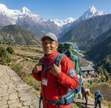
A licensed guide is mandatory for the Manaslu restricted area. Since March 2026 the former two-trekker minimum no longer applies, so solo trekkers are welcome — the guide requirement, however, is unchanged and strictly enforced. Swotah runs group departures with 2–8 trekkers. Private departures for couples or small parties are available. Guides hold Ministry of Tourism licences, have Nepal Mountaineering Association first-aid certification, and have crossed the Larkya La multiple times. One porter is assigned per two trekkers, carrying a maximum of 20–25 kg. Porter rates are USD 18–22 per day; recommended tip is NPR 1,500–2,000 per trek day.
From Namrung upward, the villages belong to Nubri Tibetan Buddhist communities whose language (Nubri, an undocumented Tibetan dialect), dress, and traditions remain largely intact. Walk clockwise around mani walls, prayer flags, and chortens. Remove boots before entering gompas. Ask permission before photographing individuals or monastery interiors. In Samagaon, the 17th-century Pungyen Gompa accepts visitors during daylight hours. The guide provides cultural context as communities change along the route.
Dal bhat (lentil soup, rice, vegetable curry, and pickles) is the main fuel on the circuit and comes with free refills at almost every teahouse. It is the most reliable and calorie-dense choice at every elevation. Above Namrung, the Tibetan cultural influence shapes the food: Tibetan butter tea (Po Cha, made from yak butter, salt, and tea leaves) is warming at cold camp temperatures. Tibetan bread (deep-fried flatbread with yak butter or honey) is a standard breakfast. Thenthuk (Tibetan hand-pulled noodle soup), Shyakpa (yak meat stew with doughy dumplings), and Churpi (hard yak cheese) are common. Momos (steamed dumplings) are available at Samagaon and below. Menu variety narrows significantly above Samagaon. Avoid meat above 3,000 m: freshness cannot be guaranteed and digesting protein at altitude adds physiological stress.
Boil water for at least one minute or use purification tablets (Aquatabs or Micropur, USD 7–20 per supply, available in Kathmandu). Boiled water at teahouses costs NPR 50–200 per cup depending on altitude. Aim for 3–4 litres per day above 3,000 m. Carry a 1-litre reusable bottle. Do not drink untreated tap, stream, or river water anywhere on the circuit. Dal bhat price at Jagat is NPR 400–500; at Samagaon NPR 800–1,000; at Dharamsala NPR 1,000–1,200.
Nepal Telecom (NTC) provides the best remote coverage. Signal is available at Machha Khola, Namrung, Lho, and partially at Samagaon. Signal disappears from Samdo to Bimthang (approximately 3 days without reliable signal). Ncell covers only the lower valley to Jagat. WiFi is available at teahouses in Machha Khola, Jagat, Deng, Namrung, and Samagaon for NPR 300–1,000 per session. Above Samagaon, WiFi is unavailable. Swotah provides a free tourist SIM card (NTC) with every booking. Purchasing NTC data: dial *400# to check balance, then *1415# to select a data pack, or use the Nepal Telecom app.
Charging is available at most lower-valley teahouses (NPR 300–600 per device), rising with altitude. Above Samagaon, solar charging is the only source and unavailable on overcast days. At Dharamsala, charging is limited to a few shared solar panels. Cold temperatures accelerate battery drain: lithium batteries lose significant capacity below −10°C. A 20,000 mAh power bank is essential for Days 10–11. For continuous emergency communication above Jagat, a Garmin inReach or SPOT satellite communicator is strongly recommended.
The Manaslu Circuit has no flight access — both ends are by road. The trek starts at Machhakhola (870 m): a private 4WD jeep covers the 160 km from Kathmandu in about 8–9 hours (a public bus to Arughat plus a local jeep is the budget alternative). The road is sealed to Dhading Besi, then unpaved and rough through Arughat and Soti Khola to Machhakhola. Private jeeps handle the terrain better and allow flexible stops. Swotah includes private jeep transfers for both legs.
The circuit exits onto the Annapurna Circuit road at Dharapani (1,860 m). From Tilje/Dharapani a 4–5 hour jeep ride down the Marsyangdi valley reaches Besi Sahar (760 m), and a further 5–6 hour drive returns to Kathmandu (about 175 km total) — usually split over two days with a night in Besi Sahar. Book transport early during peak autumn (October), when private jeep availability is tight. Eat breakfast before departure and carry packed snacks, as road stops are infrequent; bring motion-sickness medication, as the mountain roads involve sustained curves and steep descents.
The Manaslu Circuit requires the fitness to walk 5–8 hours per day for 10 consecutive trekking days on rocky, uneven terrain. Start training 3–5 months before departure. Month 1: establish a base with 3 × 30-minute walks per week, increasing to 60 minutes. Month 2: add weekend hill walks with a 10–15 kg pack. Month 3: complete at least two 2-day consecutive hikes over significant elevation. Swimming, cycling, and stair climbing build cardiovascular base; lunges, squats, and step-ups build knee stability for the long Larkya La descent. Recommended vaccinations before Nepal travel: Hepatitis A, Typhoid, Rabies, and Japanese Encephalitis (especially for monsoon-season travel).
A typical day: 5:30–6:30 am wake-up with hot tea. 7:00–7:30 am breakfast (porridge, eggs, Tibetan bread). Walk begins by 7:30 am after applying SPF 50+ sunscreen. Lunch stop 12:00–1:00 pm at a teahouse. Arrive camp 2:30–4:30 pm. Shower if available, rest, short acclimatisation walk. Dinner 6:00–7:30 pm. Bed 8:30–9:00 pm: early bedtimes are standard at altitude. 60% of the circuit is uphill (concentrated Days 3–7 and 10–11). 25% is flat near Samagaon, Samdo, and Bimthang. 15% is downhill. The most demanding individual day is Day 10 (Larkya La crossing, 24 km, 13–14 hours).
What to pack
What to pack
The full kit list. Anything we loan (sleeping bag, down jacket) is called out — bring everything else.
✓Wraparound sunglasses with UV400 or polarised lenses
✓Wide-brim sun hat for lower-valley days
✓Warm fleece or merino hat for evenings and high camp
✓Balaclava (essential for the 3 am Larkya La departure at -15°C)
✓Buff or neck gaiter
✓Sunscreen SPF 50+ and lip balm with SPF (reapply every 2 hours)
Meet The Team
Our Guides for Manaslu Circuit Trek
Experienced local guides who know every trail, village, and viewpoint on this route.
Everything trekkers ask before booking. Don't see yours? Tap Enquire — we usually reply within a few hours.
The difficulty level of the Manaslu circuit trek is high. It is considered a moderate to difficult trek in Nepal.
Spring (March to May) and autumn (late September to November) are the best seasons for the Manaslu Circuit. October offers the most stable weather and the clearest mountain views; April is the spring favourite. The monsoon (June to August) and winter (December to February) are not recommended for the full circuit.
The trek's starting point is Machhakhola, which is 870 meters (2,854 feet) above sea level.
The length of the Manaslu circuit trek is 189 kilometres (117.4 miles) and generally takes 14 days in the itinerary.
Yes. Since 22 March 2026, Nepal scrapped the old rule that required a minimum of two trekkers, so a solo traveller can now obtain the Manaslu Restricted Area Permit on their own — no need to find a partner or join a group. The one requirement that remains is a government-licensed guide, which is mandatory by law and checked at every restricted-area post. Swotah provides a licensed, Larkya-experienced guide with every booking, so solo trekkers are very welcome.
Absolutely. While a guide is mandatory for the restricted Manaslu region, a porter is also much needed.
This trek takes you around Manaslu Circuit trek's highest elevation pass, Larkya La Pass, which is approximately 5,106 meters (16,752 feet) above sea level.
Manaslu Circuit Trek is generally considered harder than Annapurna Circuit Trek due to the difference in the Highest elevation point and the noticeable jump in altitude.
A person with no prior trekking experience or physical fitness can not do the Manaslu Circuit Trek.
The Manaslu Circuit is longer, higher, more remote, and carries a fraction of the Annapurna Circuit’s visitor numbers. The Annapurna Circuit sees 80,000–100,000 trekkers per year; the Manaslu Circuit sees fewer than 8,000. The restricted-area permit creates a barrier that keeps the trail genuinely uncrowded. The cultural character is distinct: the upper valley is more fully Tibetan Buddhist, with less commercial development at the teahouses. The Annapurna Circuit has roads through its central section since 2010; the Manaslu Circuit has none above Jagat.
The Manaslu Circuit is not ideal as a first Nepal trek. The restricted area, remoteness above Namrung, 13–14 hour Larkya La day, and five consecutive nights above 3,000 m demand better fitness, cold-weather gear, and altitude experience than routes like the Annapurna Base Camp. For first-timers who are very fit with strong multi-day hill-walking experience, the circuit is possible. The Annapurna Circuit or Everest Base Camp Trek are more appropriate starting points.
Four permits are required. (1) Manaslu Restricted Area Permit (MRAP): USD 100/person for the first 7 days then USD 15/day (Sep–Nov); USD 75 then USD 10/day (Dec–Aug). (2) MCAP: NPR 3,000 (about USD 23). (3) ACAP: NPR 3,000 (about USD 23). (4) Tsum-Nubri (Chumnubri) Rural Municipality Permit: NPR 1,000 (about USD 8). A separate TIMS card is not required for the Manaslu restricted area — the MRAP replaces it. As of 22 March 2026 the old two-trekker minimum has been scrapped, so solo trekkers can obtain the permit individually, but a licensed guide is still mandatory. For this 14-day itinerary the MRAP runs about USD 115, bringing the total to roughly USD 170 per person — all arranged and included in the Swotah package.
Yes — always. The two-trekker minimum was abolished on 22 March 2026 and solo permits are now issued, but hiring a government-licensed guide remains a strict legal requirement for the Manaslu restricted area and is enforced at every checkpoint (Jagat, Philim, Namrung, Samagaon, Dharapani). Trekking without one is not allowed and risks your permit being voided. Swotah supplies a licensed, Larkya-experienced guide on every departure, and can place solo trekkers in a small group if you would prefer company.
Trekking poles with snow baskets, microspikes, a headlamp with lithium batteries, and a balaclava for the 3–4 am departure. Your sleeping bag at Dharamsala must be rated to at least −15°C. Carry a minimum of 2,000 kcal of personal snacks: there is no teahouse stop between Dharamsala and Bimthang. An extra warm mid-layer specifically for Dharamsala dinner is essential, as the stone walls offer almost no insulation from outside temperatures of −12°C to −18°C.
The Larkya La in December–February is a winter mountaineering undertaking, not a standard trekking pass. Deep snow, icy slopes, and temperatures of −20°C or below at Dharamsala make it dangerous for trekkers without cold-weather mountaineering experience, crampons, and ice axes. Swotah does not run scheduled winter full-circuit departures. Contact us if you want a winter lower-valley partial circuit.
NTC (Nepal Telecom) provides the best coverage: signal is available at Machha Khola, Namrung, Lho, and partially at Samagaon. Signal disappears from Samdo to Bimthang (approximately 3 days without reliable signal). WiFi is available at teahouses in Machha Khola, Jagat, Deng, Namrung, and Samagaon for NPR 300–1,000 per session. Above Samagaon, WiFi is unavailable. Swotah provides a free NTC tourist SIM. For continuous emergency communication above Jagat, a satellite communicator is strongly recommended.
The 14-day itinerary gains altitude gradually rather than using a separate rest day, with four staged nights between 3,000 m and 4,460 m — Syala (3,500 m), Samagaon (3,530 m), Samdo (3,875 m) and Dharamsala (4,460 m) — before the Larkya La. Samagaon is the key altitude checkpoint: your guide takes SpO2 readings there, and the push to Dharamsala depends on the result. If you would prefer an extra acclimatisation day at Samagaon (recommended if you have not trekked above 4,000 m before), we can add one on request — just tell us when you book.
Food variety narrows significantly above Samagaon. Samdo and Dharamsala offer dal bhat, noodle soup, porridge, eggs, Tibetan bread, and hot drinks. Portions at Dharamsala are smaller because all supplies are carried by porter from Samagaon. Chocolate, nuts, and energy gels are essential for the Larkya La crossing day: the first available meal is at Bimthang, approximately 13–14 hours after leaving Dharamsala.
Yes. Tsum Valley branches north from the circuit at Philim or Lokpa. An extension adds 7–9 days and requires a separate restricted-area permit (approximately USD 35–50 per person per week in high season). Tsum Valley was opened to trekkers in 2008 and is one of Nepal’s most culturally intact Tibetan Buddhist regions. The combined trip runs 22–24 days total. Contact Swotah for the combined Manaslu Circuit + Tsum Valley itinerary.
The Manaslu Circuit is one of the safer trekking routes in Nepal for female travellers. Nepal ranks among the most female-friendly destinations in South Asia. The restricted nature means far fewer trekkers and a less commercially exposed trail. Since March 2026, solo trekkers — including solo women — can obtain the permit individually, and you will always be accompanied by your licensed guide on the trail. Swotah’s guides are experienced at managing cultural dynamics and supporting solo female clients.
If you develop mild AMS symptoms (headache, nausea, dizziness), stop ascending and rest. If symptoms worsen or do not improve within 24 hours, descend 300–500 m immediately. Inform your guide of any symptoms: going through the pass with unresolved AMS is the most common serious mistake on this circuit. Your guide carries altitude medications and a pulse oximeter. Helicopter evacuation from Samagaon and Bimthang is possible but can take 24–48 hours in bad weather.
Why Travel with Swotah
Why Book the Manaslu Circuit Trek with Swotah
Most Nepal operators look the same from the outside. Here's what actually makes the difference.
Born in Nepal
100% locally owned since 2016. Trek profits stay with the mountain families and village schools along your route.
Guaranteed Departures
Every date on our calendar runs — no minimum group size. You never pay to be cancelled.
Certified Guides
Government-licensed, WFR-certified, English-speaking. Most were born within two valleys of the trail.
Small Groups
Small groups, never more than 8 trekkers. You get a real experience, not a convoy.
Gear Included
Sleeping bag and down jacket loaned at no extra charge — both rated to –20°C.
Flexible Payment
Deposit from 10% to confirm, balance before departure or in cash on arrival. Reschedule up to 30 days prior.
24/7 Support
Kathmandu office and dedicated WhatsApp emergency line. We answer at 2am if needed.
Hall of Fame
TripAdvisor Travelers' Choice 2023, 2024 and 2025. Hundreds of verified five-star reviews.
Get a free personalised travel brief for the Manaslu Circuit Trek.
Tell us your travel dates and group size. Our team in Kathmandu will put together a tailored itinerary, honest costs, and practical tips — completely free, no commitment.