Annapurna Circuit Trek Map

Annapurna Circuit Trek Map
swotah travel
8876
09, 09 2024
The Annapurna Circuit Trek is one of the most famous trekking routes in the world, known for its breathtaking landscapes, diverse cultures, and challenging yet rewarding journey.
When navigating this trek, a well-detailed map becomes your best companion. In this post, we provide an in-depth breakdown of the map, helping you understand the route, elevation, road conditions, and possible variations to the traditional trek.
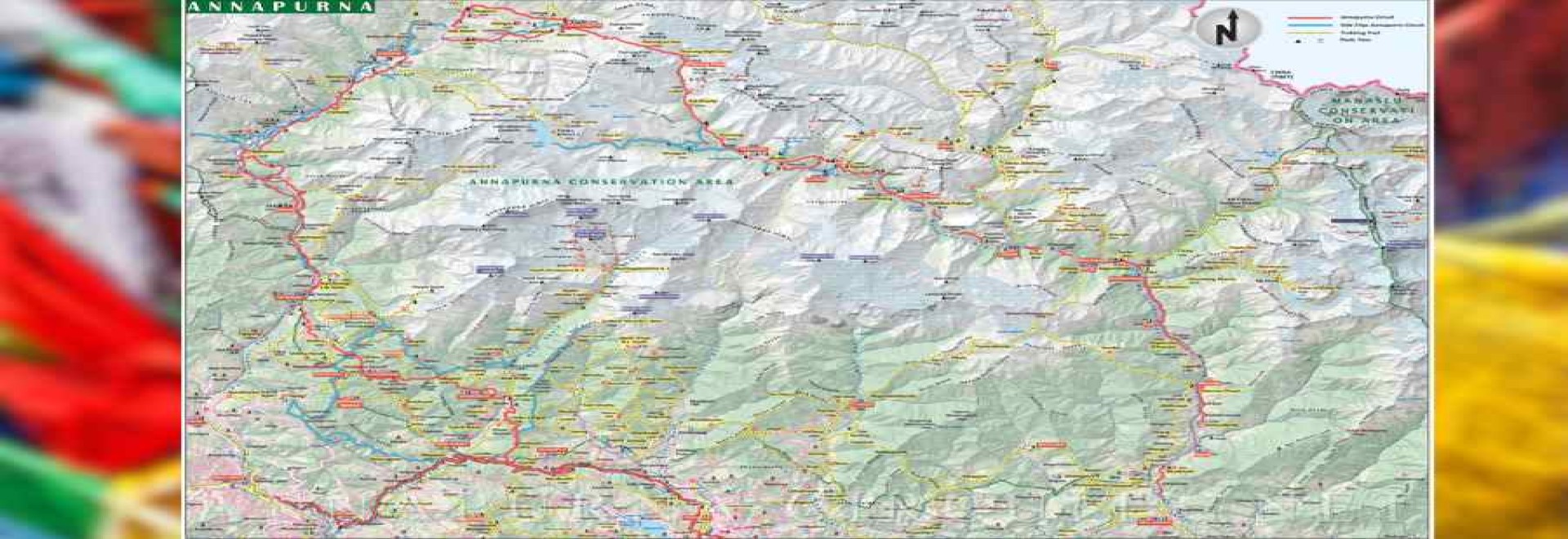
This map provides a detailed overview of the Annapurna Circuit Trek, showing the main trekking route, side trips, important landmarks, villages, and significant points like passes, peaks, and rivers.
1. Main Annapurna Circuit Route
- The red line represents the main Annapurna Circuit trekking route.
- The trek starts from Besisahar (lower right of the map) and progresses northward, following the Marshyangdi River.
- The path winds through key villages like Chame, Manang, and Thorong Phedi before reaching the highest point, the Thorong La Pass (marked in the top center of the map).
- After crossing the pass, the route descends to Muktinath and continues to Jomsom.
2. Elevation
- You can see a clear progression of elevations across the trek. Lower elevations begin in the southern region of the map around Besisahar, with more forested and agricultural landscapes.
- As you move northward, the altitude rises dramatically, especially around Manang and Thorong La Pass, the latter being the highest point at 5,416 meters.
- Post-pass, the elevation decreases steadily as you move down to Muktinath and Jomsom.
3. Side Treks and Alternative Routes
- The yellow dotted lines represent side trips and alternate trails, allowing for variations in your trek. For example:
- Tilicho Lake trek, which branches off from Manang, is one of the most famous side treks (you can spot Tilicho Lake towards the top of the map).
- Other side routes take you towards Nar Phu Valley or to less travelled paths that rejoin the main route at various points.
4. Villages and Settlements
- The map marks various villages along the way, such as Manang, Chame, and Muktinath, which are typical resting or acclimatization points.
- These villages are well-known for providing trekkers with accommodation, food, and often serve as acclimatization points to adjust to higher altitudes.
5. Road Access
- The black lines represent motorable roads that intersect the trek. For instance:
- From Besisahar to Chame, a road allows jeep access, meaning trekkers can choose to start their hike from different points based on their preferences.
- There’s also a road from Jomsom heading down towards Tatopani, which is another exit point for those looking to shorten the trek.
6. Annapurna Conservation Area
- This map highlights the trek's location within the Annapurna Conservation Area. The boundaries of this protected region are marked, emphasizing its ecological and cultural significance.
7. Geographical Features
- The gray areas on the map represent high mountain ranges, glaciers, and peaks. You can spot key landmarks like Annapurna I, Annapurna II, and other high-altitude peaks.
- Rivers and streams are also depicted, mainly following the Marshyangdi River on the eastern part of the circuit and the Kali Gandaki River on the western part.
8. Thorong La Pass and Peaks
- The map marks the location of Thorong La Pass—the highest point of the trek. Around it, you can see other high-altitude peaks and passes.
9. Nearby Regions
- In the upper right corner, you can see the Manaslu Conservation Area, which borders the Annapurna region. This area features another popular trekking destination in Nepal, the Manaslu Circuit.
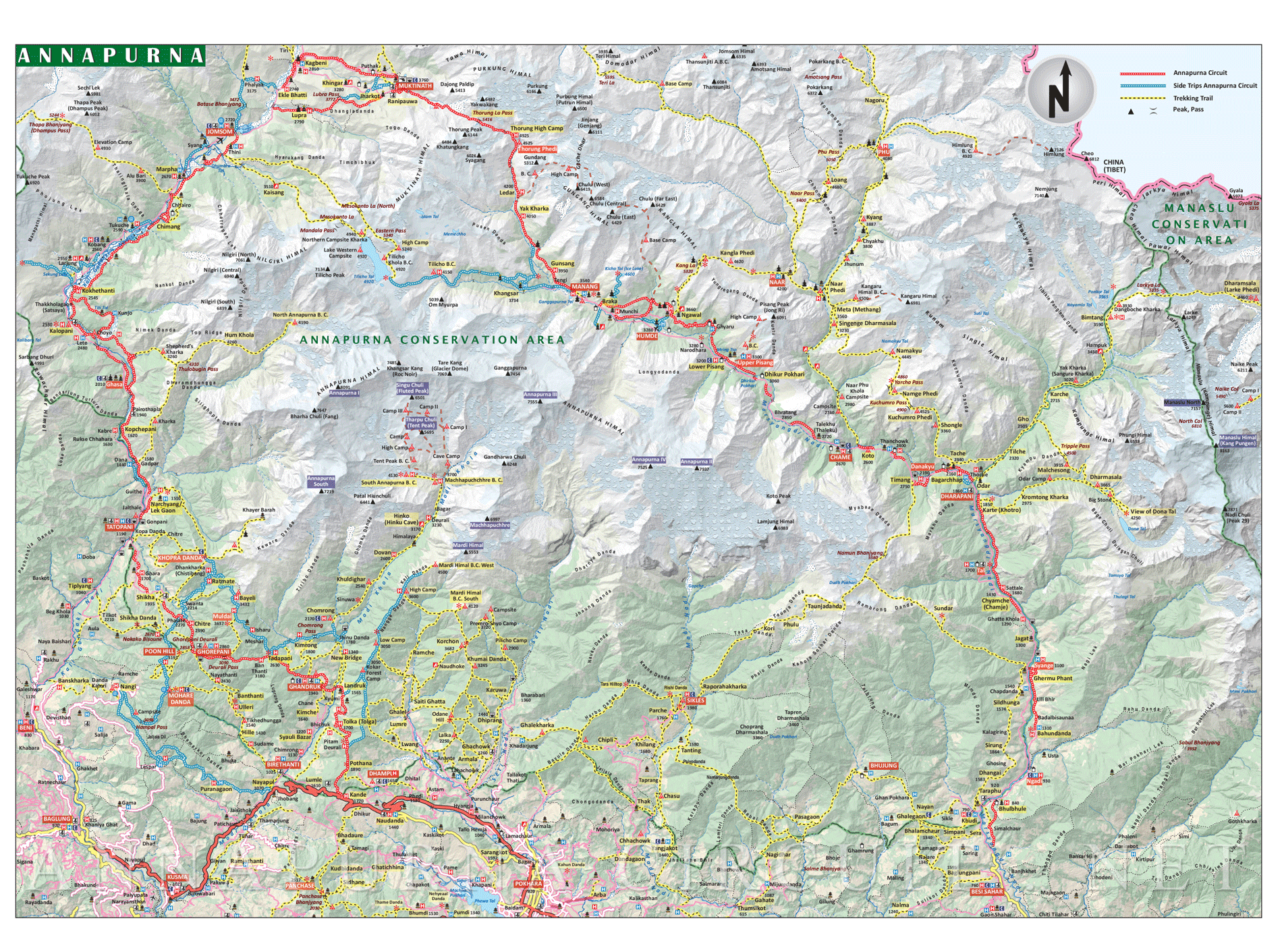
Detailed Description of the Route
The Annapurna Circuit Trek map provides a visual guide to one of the world’s most diverse and adventurous treks. Below is a detailed description of the route based on the sections visible on the map you provided:
Besisahar to Chame (Lower Marshyangdi Valley)
- Besisahar (760m) is the traditional starting point of the Annapurna Circuit. From here, the trail follows the Marshyangdi River northward, passing through several villages and forested hills.
- The route passes through Ngadi, Bahundanda, Jagat, Chamje, Tal, Dharapani, and eventually reaches Chame (2,710m), the administrative headquarters of the Manang district.
- Lower Section: The trail in this region is marked by terraced rice fields, lush forests, and waterfalls. The river gorge deepens, and you’ll cross numerous suspension bridges.
- Elevation: The trek steadily gains altitude as you progress towards Chame.
- Road Access: A jeep road now runs alongside the trekking trail from Besisahar to Chame, making it possible to shorten the trek or skip some sections via vehicles. This road is marked on the map.
Chame to Manang (Mid-Annapurna Section)
- The trail from Chame to Manang (3,540m) takes trekkers through alpine terrain, with the prominent peaks of the Annapurna range appearing on the horizon.
- The route passes through Pisang, Bhratang, Dhikur Pokhari, and Humde, before arriving at Manang, a major stop for acclimatization.
- The landscape changes dramatically from dense forests to a more arid and alpine environment. The valleys widen, and trekkers get their first clear views of peaks like Annapurna II, Gangapurna, and Tilicho Peak.
- Pisang offers two variations:
- Lower Pisang Route: Easier but less scenic, follows the valley floor.
- Upper Pisang Route: More challenging but rewards trekkers with stunning panoramic views of the Annapurna range.
Manang to Thorong Phedi/High Camp (High Altitude Trek)
- After Manang, the trail enters higher altitude regions, and acclimatization becomes crucial. The route passes through Yak Kharka (4,050m), Letdar, and finally to Thorong Phedi (4,450m) or High Camp (4,800m), the final stop before crossing the pass.
- The terrain is now barren and rocky, with sparse vegetation. Trekkers will encounter yaks, herdsmen, and stunning views of Chulu East and Thorong Peak.
- The trek becomes more demanding due to the altitude, with frequent rest breaks and acclimatization days recommended.
- The route is free of roads, so this section is purely trekking on rugged paths.
Thorong La Pass (Highest Point, 5,416m)
- Thorong La Pass is the highest point of the Annapurna Circuit Trek, connecting the Manang region with the Muktinath valley.
- The pass itself is often covered in snow, and the crossing is one of the most challenging days of the trek. Most trekkers begin before dawn to avoid strong winds and unpredictable weather.
- The pass offers stunning panoramic views of the Himalayas, including Annapurna, Dhaulagiri, and several smaller peaks.
- The descent from Thorong La is steep, leading down into the Muktinath region on the other side.
Muktinath to Jomsom (Kali Gandaki Valley)
- After crossing Thorong La Pass, the trek descends to Muktinath (3,800m), a sacred pilgrimage site for both Hindus and Buddhists. From here, the route heads toward Jomsom (2,720m), following the Kali Gandaki River.
- The descent brings trekkers into the Kali Gandaki Valley, which is part of the rain shadow region, meaning the landscape is more desert-like and dry.
- The trail passes through Kagbeni, a charming medieval village with narrow alleys, before reaching the larger town of Jomsom, which has an airport for those who want to fly back to Pokhara.
- There is also a road in this section, so trekkers can take jeeps or buses if they want to shorten the trek.
Jomsom to Tatopani and Ghorepani (Optional Lower Circuit)
- From Jomsom, trekkers can either end their trek by taking a flight to Pokhara or continue walking through the lower sections of the trek.
- The route heads south through Marpha and Khopra, famous for apple orchards and monasteries, before reaching Tatopani (1,200m), known for its natural hot springs.
- From Tatopani, a climb takes trekkers to Ghorepani (2,860m), famous for the Poon Hill viewpoint.
- The route in this section is more lush and green, with terraced fields, dense forests, and waterfalls.
- Poon Hill is a popular stop for a sunrise view of Dhaulagiri and Annapurna.
Ghorepani to Nayapul (End of the Trek)
- The final section descends from Ghorepani to Nayapul (1,070m), where the trek officially ends. From here, a short drive takes trekkers to Pokhara, a lakeside city and the usual post-trek destination.
- The descent is steep, through rhododendron forests, small villages, and cultivated farmlands. The trek ends in a lower elevation region, offering a warmer, more humid climate than the high-altitude sections.
Side Trips and Alternate Routes on the Map
- Tilicho Lake (4,919m): A side trip from Manang to the world’s highest lake, Tilicho Lake. This is an adventurous 2-3 day detour, visible on the map.
- Nar Phu Valley: An off-the-beaten-path trek that branches off from Koto. This remote valley offers an insight into traditional Himalayan culture and reconnects with the main Annapurna Circuit near Ngawal.
- Jomsom to Tatopani (via road): This section can be done by road (marked in black on the map) or on foot. Many trekkers choose to take a jeep from Jomsom to Tatopani to save time.
Key Landmarks on the Route
- Thorong La Pass: The highest point of the trek, often covered in snow.
- Muktinath Temple: A major religious site.
- Poon Hill: A popular viewpoint for stunning sunrise views.
- Manang: A cultural hub and acclimatization point.
- Jomsom: The gateway to the Mustang region and a major trekking stop with road and flight options.
Standard 14 Days Annapurna Circuit Trek Map
The Annapurna Circuit Trek generally takes 12 to 20 days to complete, but this guide focuses on the standard 14-day Annapurna Circuit Trek itinerary.
You’ll notice a blend of walking trails, side trips, and occasional drive routes marked to provide flexibility and options. This map also details important altitudes, viewpoints, and cultural landmarks like Muktinath and Tilicho Lake.
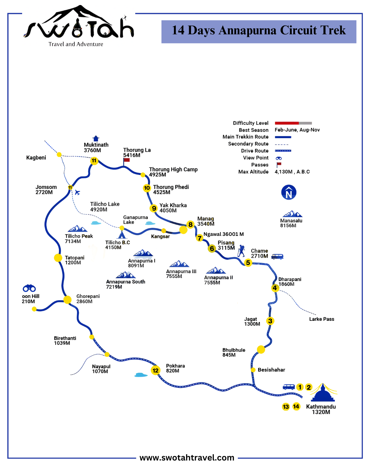
Day 1: Arrival in Kathmandu
Your adventure begins with your arrival in Kathmandu. This bustling city is not only the capital of Nepal but also the starting point for most trekking journeys in the country. Upon arrival, you’ll transfer to your hotel, where you can rest and prepare for the trek ahead. Take this opportunity to relax, explore the vibrant streets of Thamel, and prepare your gear for the trek.
Day 2: Kathmandu Sightseeing and Rest
Before starting your trek, take a day to explore the rich cultural heritage of Kathmandu. Visit UNESCO World Heritage Sites like Swayambhunath (Monkey Temple), Pashupatinath Temple, Boudhanath Stupa, and Durbar Square. This day gives you the opportunity to relax, immerse yourself in Nepal’s rich culture, and prepare mentally and physically for the trek.
Day 3: Kathmandu to Jagat (1,330 m / 4,265 ft)
On Day 3, you’ll leave the city behind and begin your journey towards the mountains. A scenic drive from Kathmandu takes you to Jagat, a small village that marks the beginning of your trek. The journey takes about 8-9 hours, offering breathtaking views of rivers, hills, and terraced farmlands along the way. Once you arrive in Jagat, you’ll check into your lodge and rest for the night, ready to start trekking the next day.
Day 4: Jagat to Dharapani (1,800 m)
The real trekking begins today as you make your way from Jagat to Dharapani. The trail passes through dense forests, crosses suspension bridges, and follows the Marshyangdi River. Along the way, you’ll encounter charming villages and waterfalls as the altitude gradually increases. The trek today is a mix of both ascents and flat sections, making it a great introduction to the circuit.
Day 5: Dharapani to Chame (2,600 m)
On Day 5, the trek takes you from Dharapani to Chame, the district headquarters of the Manang region. The trail passes through pine and oak forests and offers spectacular views of Annapurna II and Lamjung Himal. Chame is a bustling village where trekkers can find supplies and rest. The terrain becomes a bit more rugged, and the air gets cooler as you gain altitude.
Day 6: Chame to Pisang (3,200 m)
Today’s trek leads you through narrow trails carved into the cliffs, following the Marshyangdi River as it snakes through the valley. The trail climbs gradually, and as you approach Pisang, you’ll be rewarded with panoramic views of Annapurna II and III. Pisang is a beautiful village, offering trekkers the choice to stay in Lower Pisang or take an additional climb to Upper Pisang for even better views.
Day 7: Pisang to Ngawal (3,600 m)
Leaving Pisang, you’ll ascend towards Ngawal, a less-visited village on the higher route. This section of the trek offers some of the best viewpoints along the circuit. As you climb higher, the landscapes become more barren and alpine in nature. Ngawal is a peaceful village perched high above the valley floor, offering stunning views of the Annapurna range.
Day 8: Ngawal to Manang (3,500 m)
Today’s trek is relatively short and easier, allowing time to acclimatize as you head towards Manang. The landscape transitions to a more arid, desert-like environment as you enter the rain shadow of the Annapurna range. Manang is one of the largest villages on the trek, offering numerous lodges, bakeries, and even a movie hall. It’s also an important acclimatization stop, with plenty of day-hike options to explore the surrounding areas.
Day 9: Manang to Yak Kharka (4,000 m)
After spending a night in Manang, you’ll ascend to Yak Kharka, which literally translates to “yak pastures.” The trail climbs steadily, and the altitude begins to feel more noticeable. You’ll pass through open meadows where yaks graze, with the views becoming increasingly barren and alpine. This is a crucial point in the trek where altitude awareness becomes more important.
Day 10: Yak Kharka to Thorong Phedi (4,500 m)
The trail continues to climb towards Thorong Phedi, the last stop before crossing the Thorong La Pass. The trek today is relatively short but steep, with dramatic views of snow-covered peaks and glaciers. Many trekkers opt to stay at Thorong High Camp (4,925 m) for an easier ascent over the pass the next morning, but most stop at Thorong Phedi for the night.
Day 11: Thorong Phedi to Muktinath (3,760 m) via Thorong La Pass (5,416 m)
The highlight of the trek is crossing the Thorong La Pass. You’ll start early in the morning to avoid the high winds that typically pick up later in the day. The ascent is challenging, but reaching the summit of Thorong La (5,416 m) offers incredible panoramic views of the surrounding peaks. After crossing the pass, you’ll make a long descent to Muktinath, a sacred pilgrimage site for both Hindus and Buddhists.
Day 12: Muktinath to Jomsom (2,720 m)
After visiting the Muktinath Temple, the trail descends through the Kali Gandaki Valley, passing through Kagbeni and finally reaching Jomsom. This region is known for its dry, desert-like landscapes and strong winds. Jomsom is a large town with road access and an airport, offering trekkers a chance to rest and explore before heading towards Pokhara.
Day 13: Jomsom to Pokhara (820 m)
On Day 13, you’ll take a short flight or drive from Jomsom to Pokhara, a beautiful lakeside city and a popular stop for trekkers post-trek. In Pokhara, you can enjoy a well-deserved rest, explore Phewa Lake, and reflect on the incredible journey you’ve just completed.
Day 14: Departure from Kathmandu
After spending some time in Pokhara, you’ll either fly or drive back to Kathmandu for your departure. Use this final day to explore more of Kathmandu’s cultural sights or do some last-minute souvenir shopping before heading home.
Elevation Profile Annapurna Circuit Trek
| Day | Start Point | End Point | Elevation Gain (meters) | Start Elevation | End Elevation |
|---|---|---|---|---|---|
|
Day 1 |
Kathmandu (arrival) |
Kathmandu |
- |
1,320 m |
1,320 m |
|
Day 2 |
Kathmandu (sightseeing) |
Kathmandu |
- |
1,320 m |
1,320 m |
|
Day 3 |
Kathmandu |
Jagat |
+1,330 m |
1,320 m |
1,330 m |
|
Day 4 |
Jagat |
Dharapani |
+470 m |
1,330 m |
1,800 m |
|
Day 5 |
Dharapani |
Chame |
+800 m |
1,800 m |
2,600 m |
|
Day 6 |
Chame |
Pisang |
+600 m |
2,600 m |
3,200 m |
|
Day 7 |
Pisang |
Ngawal |
+400 m |
3,200 m |
3,600 m |
|
Day 8 |
Ngawal |
Manang |
-100 m |
3,600 m |
3,500 m |
|
Day 9 |
Manang |
Yak Kharka |
+500 m |
3,500 m |
4,000 m |
|
Day 10 |
Yak Kharka |
Thorong Phedi |
+500 m |
4,000 m |
4,500 m |
|
Day 11 |
Thorong Phedi |
Muktinath (via Thorong La Pass) |
-1,656 m |
4,500 m (5,416 m at pass) |
3,760 m |
|
Day 12 |
Muktinath |
Jomsom |
-1,040 m |
3,760 m |
2,720 m |
|
Day 13 |
Jomsom |
Pokhara |
-1,900 m (by flight/drive) |
2,720 m |
820 m |
|
Day 14 |
Pokhara |
Kathmandu (departure) |
- |
820 m |
1,320 m |
Road Construction and Its Impact
Roads now extend into much of the lower Annapurna region, providing vehicle access up to Chame. This road construction, while improving access for locals and reducing isolation, has also brought changes to the trek. Parts of the trail that once offered quiet mountain paths now have sections shared with vehicles, making it dustier and noisier. Despite this, many alternative trekking paths still exist, such as the Natural Annapurna Trekking Trails (NATT), which bypass the roads and keep you on the scenic, quieter trails.
Starting Points:
Given the road network, trekkers can now choose different starting points depending on their preferences:
- Besisahar: The traditional starting point, but many trekkers now opt to take a jeep from here to Syange or Chame to avoid the road section.
- Syange (1,100m): Often chosen as a starting point by those who want to avoid walking the road from Besisahar.
- Chame (2,600m): If you prefer to skip the lower-altitude trekking altogether, you can start your trek from Chame, reached by road, and dive straight into the higher-altitude part of the trek.
These road developments mean trekkers have more flexibility in deciding how much of the trail they wish to hike or drive, but it’s essential to research routes carefully to avoid the busiest road sections and still enjoy the serenity and beauty that the Annapurna Circuit is known for.
NEWSLETTER SIGNUP
Sign up to receive our trip ideas and travel offers!
Get updates and Exclusive Offers up to 20% Discount