Chitlang Kulekhani Hiking is a 7-day hike just southwest of Kathmandu that links three very different Nepali landscapes: the heritage Newar village of Chitlang, the Indrasarovar reservoir (the largest manmade lake in Nepal, built for the Kulekhani hydropower project), and the hilltop station of Daman at around 2,322 m, one of the best panorama points in central Nepal. The route follows the old southern trade road over the Chandragiri ridge at approximately 2,551 m, a path used for centuries before the Tribhuvan Highway changed commerce for good.
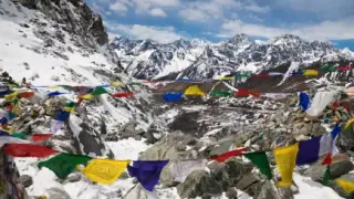
From Kathmandu you drive to Thankot and walk 11.7 km, climbing to the Chandragiri ridge at around 2,551 m before descending into Makawanpur district to reach Chitlang village (about 1,833 m), home to a Newar community that still farms terraced fields and runs Nepal's first goat-cheese factory. The next day drops to Markhu on the Kulekhani lakeshore, passing through Tamang, Newar and Brahmin farming settlements. Day 4 crosses the dam bridge and climbs to Daman, where the horizon on a clear morning shows Dhaulagiri, Annapurna, Manaslu, Ganesh Himal, Gauri Shankar, Jugal Himal, Dorje Lakpa and Everest, a panorama that is hard to match at such a short distance from Kathmandu. You return to Kathmandu on day 5.
The hike peaks at the Chandragiri ridge crossing (approximately 2,551 m) on day 2, so altitude is not a concern for acclimatised adults. Daily walking is 3 to 5 hours on forest trails, agricultural paths and the old stone trade road. No technical skill or previous trekking experience is needed. The sections below cover the best season to go, what permits are required, how accommodation and food work on route, and what to pack.

.webp)